NOAA Global Hydro Estimator
Overview
Global rainfall estimates in 15-minute intervals.
The NOAA Global Hydro Estimator (GHE) program produces estimates of global (between -60° and +60° latitude) precipitation every 15 minutes, at ~4km resolution. Estimates are derived from satellite imagery and data from NOAA’s Global Forecast System; details about the GHE algorithm are available here.
This dataset is available on Azure thanks to the NOAA Open Data Dissemination (NODD) Program.
Storage resources
Data are stored in blobs in gzip’d NetCDF format in the East US data center, in the following blob container:
https://ghe.blob.core.windows.net/noaa-ghe
Within that container, data are named as:
[product]/[year]/[month]/[day]/[filename]
- product is a product name; this should always be “rainfall”
- year is a four-digit year
- month is a two-digit month-of-year code, starting with 01
- day is a two-digit day-of-month code, starting with 01
- filename encodes the product, date, and time, with the last four digits encoding 24-hour time on 15-minute boundaries
For example, this filename:
https://ghe.blob.core.windows.net/noaa-ghe/rain_rate/2020/04/02/NPR.GEO.GHE.v1.S202004020030.nc.gz
…contains the 15-minute rainfall estimate for April 2, 2020, at 00:30 UTC.
Latitude and longitude are not perfectly uniformly sampled, so an additional file is available to specify the precise lat/lon grid associated with all GHE files (~160MB):
https://ghe.blob.core.windows.net/noaa-ghe/NPR.GEO.GHE.v1.Navigation.netcdf.gz
We also provide an API to get read-only SAS (shared access signature) tokens to allow access via, e.g., BlobFuse, which allows you to mount blob containers as drives:
https://planetarycomputer.microsoft.com/api/sas/v1/token/ghe/noaa-ghe
API documentation is at https://planetarycomputer.microsoft.com/api/sas/v1/docs.
Mounting instructions for Linux are here.
Large-scale processing using this dataset is best performed in the East US Azure data center, where the data is stored.
Sample code
A complete Python example of accessing and plotting a GHE image (i.e., an instantaneous global estimate) is available in the accompanying sample notebook.
Pretty picture
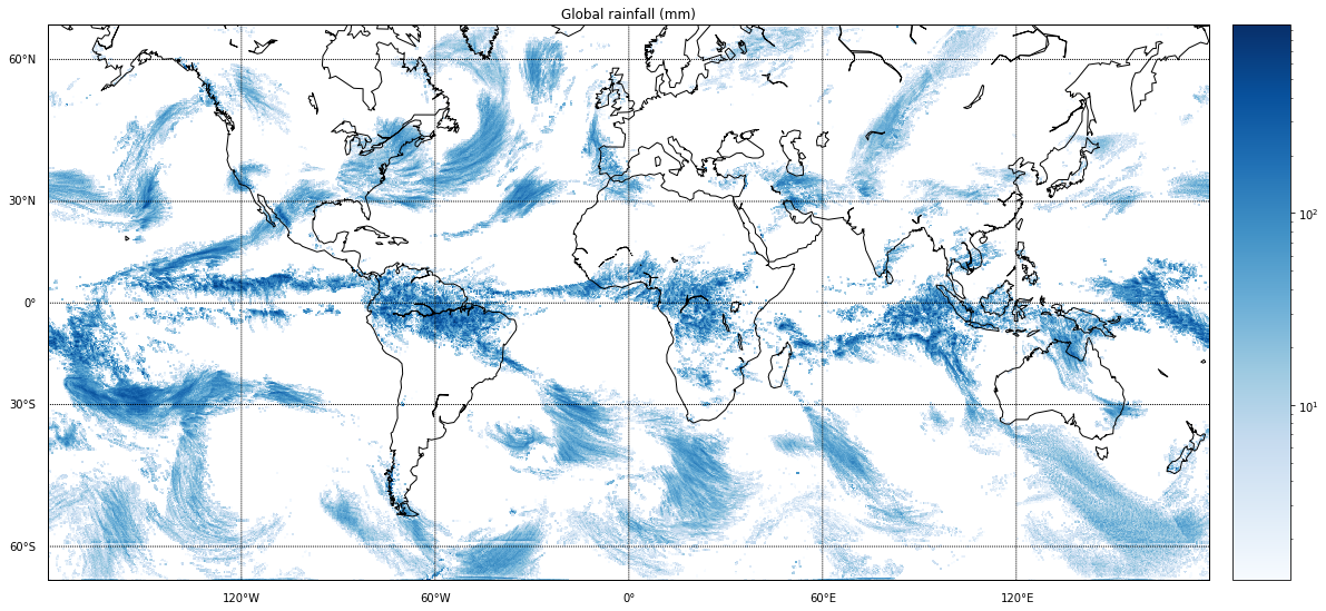
Global daily precipitation on April 9, 2020.
Contact
For questions about this dataset, contact aiforearthdatasets@microsoft.com.
Notices
Microsoft provides this dataset on an “as is” basis. Microsoft makes no warranties (express or implied), guarantees, or conditions with respect to your use of the dataset. To the extent permitted under your local law, Microsoft disclaims all liability for any damages or losses - including direct, consequential, special, indirect, incidental, or punitive - resulting from your use of this dataset. This dataset is provided under the original terms that Microsoft received source data.