NOAA GOES-R
Some of these datasets are also queryable through the Planetary Computer’s STAC API. We recommend getting the URLs in Blob Storage through the STAC API wherever possible.
Overview
Weather imagery from the GOES-16, GOES-17, and GOES-18 satellites.
The GOES-R (Geostationary Operational Environmental Satellite) program images weather phenomena from a set of satellites in geostationary orbits. The GOES-16 and GOES-17 satellites are the first two of four planned GOES-R satellites.
This dataset currently includes eleven level-2 products from the Advanced Baseline Imager (ABI) instrument, and one level-2 product from the Geostationary Lightning Mapper (GLM) instrument. We may on-board other GOES-16 and GOES-17 products on request; please contact aiforearthdatasets@microsoft.com if you are interested in using additional GOES data on Azure.
This dataset is available on Azure thanks to the NOAA Open Data Dissemination (NODD) Program.
GOES-R data is also available as a collection in the Planetary Computer Data Catalog.
See these introductory slides for more overview information:
Products available
The following GOES-R products are available on Azure, for both GOES-16 and GOES-17:
- ABI-L2-CMIPC (Advanced Baseline Imager Level 2 Cloud and Moisture Imagery CONUS)
- ABI-L2-CMIPF (Advanced Baseline Imager Level 2 Cloud and Moisture Imagery Full Disk)
- ABI-L2-CMIPM (Advanced Baseline Imager Level 2 Cloud and Moisture Imagery Mesoscale)
- ABI-L2-FDCC (Advanced Baseline Imager Level 2 Fire (Hot Spot Characterization) CONUS)
- ABI-L2-FDCF (Advanced Baseline Imager Level 2 Fire (Hot Spot Characterization) Full Disk)
- ABI-L2-LSTC (Advanced Baseline Imager Level 2 Land Surface Temperature CONUS)
- ABI-L2-LSTF (Advanced Baseline Imager Level 2 Land Surface Temperature Full Disk)
- ABI-L2-LSTM (Advanced Baseline Imager Level 2 Land Surface Temperature Mesoscale)
- ABI-L2-MCMIPC (Advanced Baseline Imager Level 2 Cloud and Moisture Imagery CONUS)
- ABI-L2-MCMIPF (Advanced Baseline Imager Level 2 Cloud and Moisture Imagery Full Disk)
- ABI-L2-MCMIPM (Advanced Baseline Imager Level 2 Cloud and Moisture Imagery Mesoscale)
- ABI-L2-RRQPEF (Advanced Baseline Imager Level 2 Rainfall Rate (Quantitative Precipitation Estimate) Full Disk)
- ABI-L2-SSTF (Advanced Baseline Imager Level 2 Sea Surface (Skin) Temperature Full Disk)
- GLM-L2-LCFA (Geostationary Lightning Mapper Level 2 Lightning Detection)
Storage resources
Data are available in Blob Storage in the West Europe Azure data center1, in both NetCDF and cloud-optimized GeoTIFF (COG) format.
NetCDF files (one file per scene) are available in the following containers, for GOES-16, GOES-17, and GOES-18 respectively:
https://goeseuwest.blob.core.windows.net/noaa-goes16
https://goeseuwest.blob.core.windows.net/noaa-goes17
https://goeseuwest.blob.core.windows.net/noaa-goes18
COG files (one file per band) are available in the following folders, for GOES-16, GOES-17, and GOES-18 respectively:
https://goeseuwest.blob.core.windows.net/noaa-goes-cogs/goes-16/
https://goeseuwest.blob.core.windows.net/noaa-goes-cogs/goes-17/
https://goeseuwest.blob.core.windows.net/noaa-goes-cogs/goes-18/
Within any of the above, data are named as:
[product]/[year]/[day]/[hour]/[filename]
- product is a product name, see the storage resources page for a list of available products
- year is a four-digit year
- day is a three-digit day-of-year code, starting with 001
- hour is a two-digit hour-of-day code, starting with 00
- filename encodes the product, date, and time; details are available in the GOES Users’ Guide
For example, this file:
https://goeseuwest.blob.core.windows.net/noaa-goes16/ABI-L2-MCMIPF/2020/003/00/OR_ABI-L2-MCMIPF-M6_G16_s20200030000215_e20200030009534_c20200030010031.nc
…contains data from January 3, 2020, between midnight and 1am UTC (hour 00).
This is the prefix for the same scene in COG format:
https://goeseuwest.blob.core.windows.net/noaa-goes16/ABI-L2-MCMIPF/2020/003/00/OR_ABI-L2-MCMIPF-M6_G16_s20200030000215_e20200030009534_c20200030010031
…and this is the COG file representing the first band from that scene:
https://goeseuwest.blob.core.windows.net/noaa-goes16/ABI-L2-MCMIPF/2020/003/00/OR_ABI-L2-MCMIPF-M6_G16_s20200030000215_e20200030009534_c20200030010031_CMI_C01.tif
Data channels and wavelengths are described here.
Large-scale processing using this dataset is best performed in the West Europe Azure data center, where the data is stored.
East US subset
1The following products are also available in the East US Azure data center, in NetCDF format:
- GOES-16 ABI-L1b-RadF
- GOES-16 ABI-L2-MCMIPF
- GOES-16 and GOES-17 GLM-L2-LCFA
Storage containers for this subset are as follows:
https://goes.blob.core.windows.net/noaa-goes16
https://goes.blob.core.windows.net/noaa-goes17
Authentication
NetCDF files do not require authentication; COG files require a Shared Access Signature token, available via our Planetary Computer token API.
Sample code
A complete Python example of accessing and plotting a GOES-16 image is available in the accompanying sample notebook.
Citation
If you use this data in a publication, please cite as:
GOES-R Series Program, (2019): NOAA GOES-R Series Advanced Baseline Imager (ABI) Level 0 Data. [indicate subset used]. NOAA National Centers for Environmental Information. doi:10.25921/tvws-w071.
Pretty picture

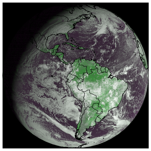
Moisture imagery of the Americas on Jan 2, 2020.
Contact
For questions about this dataset, contact aiforearthdatasets@microsoft.com.
Notices
Microsoft provides this dataset on an “as is” basis. Microsoft makes no warranties (express or implied), guarantees, or conditions with respect to your use of the dataset. To the extent permitted under your local law, Microsoft disclaims all liability for any damages or losses - including direct, consequential, special, indirect, incidental, or punitive - resulting from your use of this dataset. This dataset is provided under the original terms that Microsoft received source data.