
Profiles
AI for Earth supports organizations all around the world that are working on challenges in biodiversity conservation, climate change, agriculture, and water. Read more about the AI for Earth grantees and the amazing projects they’re working on in environmental sustainability.
-
ATREE
Building a biodiversity atlas for northeast India
The Ashoka Trust for Research in Ecology and Environment (ATREE) plans to use machine learning and computer vision to boost its efforts to map and catalog the unique, resource-rich ecosystem of northeast India. Armed with detailed satellite images of the region and the AI for Earth grant, the team believes AI-enabled tools will help them create a comprehensive database of biodiversity to help policymakers and local communities make better-informed economic, ecological, and infrastructure-related decisions.
-
Aberystwyth University, To the Poles
Gaining a better understanding of Earth’s melting glaciers
Joseph Cook, a polar scientist from the United Kingdom, is applying machine learning to optical data from drones and satellites to explore the changing cryosphere of Arctic glaciers. By training the algorithms to recognize how the different surfaces reflect certain wavelengths of light — wavelengths that can be measured by satellites as well as by drones — precision study of vast areas becomes feasible. After testing the algorithms on imagery from custom-built drones, Cook’s team will then apply them to satellite remote-sensing data, enabling them to scale up to entire glaciers.
-
AdaViv
Using AI to unleash the potential of urban agriculture
AdaViv is developing an adaptive and efficient indoor growing system on Azure that uses sensors, actuators, and machine learning to monitor plant growth, predict yields, detect diseases, and understand precisely how nutrients, environment and light are affecting plant growth. This system will help indoor producers attain higher yields, precise quality control, and hyper-efficient production.
-
African Parks
Creating smart, connected parks with cloud and AI
Managing vast territories with dispersed endangered animal populations is a logistical feat, especially in regions with political instability and poaching. For two decades, the nonprofit African Parks has served as steward for parks across Africa that would otherwise lack the resources to protect vulnerable animal populations. Cloud connectivity has transformed African Parks’ management approach from ad hoc interventions by roving rangers into a centralized command center from which the park manager can coordinate operations. African Parks uses Microsoft cloud and AI tools to track elephants, detect threats to them, and coordinate an effective ranger response to protect the animals from poaching or illegal hunting. With machine learning, park managers also hope to better understand and even predict elephant behavior. As low Earth orbit satellite constellations bring internet connectivity to the most remote regions, African Parks is poised to create smart, connected parks that are true sanctuaries for vulnerable endangered species like elephants, tigers, hyenas, and Kordofan giraffes.
-
Ag-Analytics
Improving agriculture forecasting and conservation practices
Professor Joshua Woodard launched Ag-Analytics, a service integrated with the John Deere Operations Center that provides intelligent, easy-to-use tools to help farmers plan and monitor their crops. Ag-Analytics brings together data from farm machinery sensors with other datasets such as weather and satellite imagery to develop models for yield and crop cover forecasting. This information and more accurate forecasting can help shape policies to make it economically feasible (through insurance subsidies) for farmers to implement conservation practices.
-
Agrimetrics
Accelerating innovation in agri-food by linking data
The agri-food sector is one of the least digitized industries in the world, with many barriers to collecting, sharing, and using data. Agrimetrics was founded to accelerate innovation in the agri-food industry by connecting data and thus enabling advanced analytics and AI. Their goal is to help agri-food businesses produce food more efficiently and sustainably. As a long-time Microsoft Partner, Agrimetrics uses Microsoft Azure technology to power an agri-food Data Marketplace. This Data Marketplace lets data providers, from farmers to global corporations, market and manage their data, and helps data consumers, from researchers to businesses and government organizations, to find and use that data. Agrimetrics is now working with the AI for Earth program to forge new collaborations, such as with other AI for Earth grantees, and extend its capabilities to deploy innovative, sustainable, and scalable solutions to environmental and agricultural problems around the world.
-
Aquaveo
Solving the challenge of increasing flood frequency and severity in developing countries
Michael Souffront, a software engineer at Aquaveo, developed a high-density hydrologic model and visualization tool for forecasting global floods. The GloFAS-RAPID model produces streamflow forecasts not just from major rivers, but also medium-sized and smaller streams — helping advance flood preparedness, especially in developing countries.
-
Breeze Technologies
Applying AI to improve the accuracy of air quality measurements
Air pollution is the single biggest environmental health threat of our time, killing 7 million people and costing the world economy USD5 trillion per year. Data-driven decision-making around air pollution mitigation has been unfeasible, as traditional sensing equipment is expensive, stakeholders lack necessary knowledge to analyze the data, and suitable interventions are difficult to define. Breeze Technologies aims to deliver hyperlocal comprehensive and accurate air quality data from public and private data sources and low-cost sensors, as well as insights based on recent scientific studies and actionable recommendations from a growing, self-learning catalog of more than 3,500 air quality interventions.
-
Carnegie Mellon University
Countering poaching with adaptable AI
Poaching is one of the greatest threats to wildlife conservation and is very difficult to prevent. Rangers have had to develop their own skills and intuitions through years of field experience, and they lacked modern technological tools that could help them make better decisions. PAWS, developed by Dr. Fei Fang of Carnegie Mellon University, is an AI tool that uses machine learning and behavior modeling to help rangers plan more effective patrol routines. Through a Microsoft AI for Earth grant, Dr. Fang took the next step in developing PAWS by adding real-time interactive tools that can take new information from the rangers on patrol and offer updated strategies for tracking down poachers.
-
Chloris Geospatial
Using spaceborne sensors and AI to measure forest biomass
In the wake of Glasgow COP26, world leaders are aligned in their commitment to reduce atmospheric carbon and keep global warming below the critical 1.5°C threshold. Making good on this promise requires changing the way forests and landscapes are managed. Microsoft Planetary Computer partner Chloris Geospatial has developed a unique technology that goes beyond monitoring forest cover—the traditional monitoring approach—to measure directly the growth and degradation of above-ground biomass over time, providing accurate, global measurements of a crucial component of earth’s carbon stock. Chloris’ proprietary solution uses satellite data and machine learning to transform how forests and other ecosystems are monitored. At 30-meter resolution, it offers accurate insight into changing carbon stock at the global, national, regional, and even the project level.
-
City University of New York
Furthering oceanographic study with the Microsoft cloud
The Ocean Observatories Initiative (OOI) Cabled Array collects large quantities of data from the seafloor and overlying ocean environment of the Juan de Fuca tectonic plate in the northeast Pacific — providing a valuable opportunity for researchers and students to learn more about the ocean and seafloor processes. But currently, downloading and processing the data on local computers takes days or even weeks. With funding from the Microsoft AI for Earth program, Dr. Timothy Crone and Dr. Dax Soule are helping make this data more accessible and usable to scientists and students around the globe by building a Microsoft cloud-based system on Pangeo, an open-source platform for big data geoscience. Increasing access to technology is a passion for Dr. Soule. At the City University of New York (CUNY), he teaches students from very diverse ethnic and economic backgrounds that are often not well-represented in science-related careers. Through the partnership with Microsoft, Dr. Soule and his students now have the cloud-based tools they need to access and work with the OOI Cabled Array data, conducting important research and becoming the next generation of oceanographic scientists.
-
CoCoRaHS Network, Colorado State University
Enhancing climate data and research with AI
Precipitation can vary a lot over surprisingly small distances, as demonstrated by the Spring Creek flood in Fort Collins, Colorado, in 1997, when 14.5 inches of rain fell in a highly concentrated area and caused a deadly flash flood in nearby neighborhoods that had significantly less rain. From that disaster was born the Collaborative Community Rain, Snow, and Hail Network — CoCoRaHS for short — which works with thousands of volunteers to gather daily data on precipitation. CoCoRaHS provides small-scale coverage that helps weather services issue timely alerts on severe weather conditions that can save lives, and its accumulated records also help other organizations, from climatology to agriculture, engineering, and insurance, with long-term planning. Now thanks to a Microsoft AI for Earth grant, CoCoRaHS is improving the quality of its reports through AI, pulling more information out of the reports with natural language processing, and making that data more available through Azure Notebooks and Power BI.
-
Columbia University
Keeping a close watch on our forests, for our future
Professors Tian Zheng and Maria Uriarte at Columbia University are using ground observations of forest plots to create a machine learning pipeline that’s capable of correctly classifying the species of individual trees using aerial photographs and LiDAR data collected by NASA using remote sensing technologies, in order to better understand how storms affect a forest’s ability to store carbon and aid in climate change mitigation, and how damaged forests recover over time.
-
Conservation Metrics
Closing the gap between field work and analysis
Conservation Metrics is developing automated solutions using Microsoft Azure that collect, process, and analyze terabytes of wildlife data. By moving its infrastructure to Azure, Conservation Metrics hopes to give researchers more time and resources to meet their conservation goals by significantly closing the gap between field work and information and discovery.
-
Conservation Science Partners
Protecting forest and water resources with AI
Forests in the western United States are suffering increasing tree losses due to several causes, including droughts from climate change, wildfires, and beetle infestations. This loss of trees is a serious problem not only for maintaining carbon storage, but also for the availability of water resources, as forests play an important role in replenishing local watersheds. A regional-scale analysis of forest disturbances and their impact on water resources changes is necessary to better understand and manage these issues. With recent advances in AI, machine learning, and cloud computing, it’s now possible to combine satellite imagery at medium and high resolutions and analyze this data to see how the forest cover across the region changes from disturbance events. Additionally, that analysis can be correlated to water supply records to understand those impacts as well. Through the insights gained from this study, local communities, regional organizations, and the federal government can better manage and protect these vital resources.
-
Cornell University Center for Conservation Bioacoustics
Monitoring insect sounds in tropical rainforests
Led by Holger Klinck and Laurel Symes of Cornell University’s Bioacoustics Research Program, a team of researchers is looking to AI-powered acoustic monitoring of insects as a way of better understanding the dynamics of rainforest habitats. The team is focusing first on neotropical rainforest katydids, a diverse group that occupies a central position in tropical food webs. How the wide variety of katydids interacts with the rest of the forest species, both plants and animals, can provide lots of information about the overall ecosystem. Klinck aims to scale beyond insects to other species, including birds, monkeys, and other vocal animals, to help advance conservation of tropical rainforests.
-
DHI GRAS
Improving crop water efficiency in Uganda
At DHI GRAS, Dr. Torsten Bondo and Dr. Radoslaw Guzinski — a small Denmark-based company focused on Earth observation and satellite imaging — are using machine learning and satellite remote sensing to measure the rate of water evaporation from soil and plant surfaces into the atmosphere from fields. Their goal is to help Ugandan farmers reduce water use by knowing more precisely how much water their crops really need.
-
Digamma.ai
Classifying land cover to improve maps of landslide susceptibility, water, and carbon storage
Due to technological advances, scientists can now capture data on Earth and off-world at rates that greatly exceed the ability to interpret it. These massive datasets challenge the delivery of timely maps and analysis to the nation. Artificial intelligence (AI) tools, including machine learning, allow us to rapidly interpret these data sets to solve national challenges. Digamma.ai and the U.S. Geological Survey’s National Innovation Center (USGS NIC) are using machine learning to dramatically improve land cover models, with the intent of improving maps of landslide susceptibility, water, and carbon storage. In addressing this challenge, Digamma.ai used geologic mapping and USDA imagery to train machine learning models to discriminate between bare rock and exposed soil, improving land-cover maps across the Sierra Nevada in California.
-
Dr. Monique Mackenzie, University of St. Andrews
Saving endangered vultures through AI modeling
Vultures perform essential ecosystem services by scavenging on dead animals, which is crucial in preventing the spread of disease to other animals and humans. However, deliberately poisoned carcasses—a result of human-wildlife conflict—can result in several hundred vulture deaths at a single poisoned carcass. Dr. Monique Mackenzie, a statistician and Provost at the University of St. Andrews in the United Kingdom, is working with a team in Namibia to stop the decline of the vulture population. By analyzing the locations and activity of GSM/satellite tagged animals which locate carcasses as part of normal foraging behavior, the team can quickly locate and attend to the carcasses, preventing many deaths. Through an AI for Earth grant, Dr. Mackenzie can help the team upscale their solution and create lasting impact.
-
Duke University
Monitoring climate change in the Antarctic with machine learning
Climate change is disrupting the pristine ecosystem around the western Antarctic peninsula, a globally significant center of biodiversity based around the presence of krill that provide sustenance for many other species. Many of the world’s whales spend their summers here as their primary feeding grounds. By monitoring the size and health of the whales, it’s possible to gain insights on the abundance of krill and the ecosystem as a whole. Satellites and drones now enable vast amounts of image and video data on the whales to be collected — more than could ever be efficiently processed by people. The Duke University Mobile Robotics and Remote Sensing Lab is developing machine learning models on Microsoft Azure that can manage this massive data and quickly provide the statistics needed to help further research and environmental protection efforts. Making these models available as APIs on Azure will also enable other researchers to improve their work.
-
ETH Zurich
Fighting deforestation with deep learning and smart contracts
Deforestation is one of the significant contributors of greenhouse gases and drivers of climate change. Much of that deforestation comes from local farmers trying to make their living, which presents the possibility of combating it by offering financial incentives to preserve the trees. In many areas, such as the Amazon forest, it would be too time-consuming and difficult to determine who has the legal claim to be the caretaker for a particular section of forest. AI researcher David Dao and his team came up with an innovative alternative: help make everyone a caretaker of the forest by letting anyone put a financial stake in its well-being and earning a higher repayment when it is conserved. Through AI technologies on Microsoft Azure, including machine learning and blockchain-enabled smart contracts, Dao was able to make this concept, GainForest, a reality.
-
EcoHealth Alliance
Tracking diseases through scientific literature with AI
As new infectious diseases emerge and spread in different areas of the world, tracking the outbreaks is an important step in analyzing where they might emerge or spread next. Archives of scientific publications such as PubMed Central present a resource for monitoring this information, but with thousands and thousands of articles published annually without a common standard for presenting data, extracting that data is very challenging. EcoHealth Alliance, an international nonprofit organization dedicated to preventing pandemics and protecting both human lives and wildlife, is turning to AI to meet this challenge. With assistance from a Microsoft AI for Earth grant, EcoHealth Alliance is developing PubCrawler, an AI-based software project that uses natural language processing to produce high-resolution datasets of the locations where research is being done into various diseases. The tools of this project also can be applied more broadly to meet other needs in biodiversity and conservation research.
-
Farming Online
Optimizing coffee harvesting with AI
Coffee farming is a financially risky effort because the coffee berries ripen at varying rates even on the same tree branch, making it challenging to avoid a wasteful amount of underripe or overripe fruit. Climate change is increasing that risk by reducing yields and quality, increasing pests and diseases, and even making farmlands untenable. These changes are not merely an inconvenience for coffee drinkers around the world, but represent a serious threat to the livelihood of tens of millions of small-scale farmers in developing nations. Farming Online is working to mitigate that risk by enabling farmers to harvest a higher proportion of fully ripe coffee. Through a Microsoft AI for Earth grant, the Farming Online team is developing a machine learning model and smartphone app that will let farm workers in the field use photos of the coffee berries and current weather data to predict the best time to harvest.
-
Harrison Atelier
Pollinators Pavilion
Unlike the familiar honeybees which live together in hives, most bee species are solitary and therefore difficult to study. These solitary bees also play a far greater role in pollination than is commonly known, and understanding their lives is important to managing biodiversity and conservation efforts. For that purpose, Dr. Ariane Harrison and her team at Harrison Atelier created the Pollinators Pavilion, a prototype field station and educational tool that provides an artificial habitat and monitoring station for 2,000 solitary bees. Using automated cameras and machine learning analysis, the Pavilion will help researchers better study the bees, while also providing a means for the public to learn more about these important pollinators as well.
-
HighTide Intelligence
Understanding the risk of sea level rise to populations
Sea levels are rising and the impact on coastal communities will be far reaching. Though most communities are aware and conceptually understand what it could mean to local infrastructure, very few are focusing on addressing the inevitable challenges this will bring to individuals. HighTide Intelligence is quantifying the financial impact of climate-driven flooding with the goal of preparing people and cities to understand the risks and measures required to adapt to changing climates
-
IIIT Delhi
Developing an intelligent tool for monitoring monkey populations
Ankita Shukla’s and a team at IIIT Delhi are developing an intelligent tool to monitor and control rapidly growing urban monkey populations. The tool will use Microsoft cloud and AI tools to detect and identify individual monkeys from images captured by photographers and camera traps, helping researchers identify and find monkeys needing sterilization and distribute contraceptive-laden food.
-
Imazon
Enabling equitable water distribution to residents in megacities
The vastness of the Amazon means that identifying and understanding trends there can be a daunting task. While images were available for processing, the initial process was highly manual and time consuming. And while image processing computer models was available, the sheer volume meant that the computing power required was significant. Using Microsoft Azure, image recognition became scalable to larger geographies in order to locate and predict fires and deforestation. This prediction allows governments and NGOs to better inform their budgets and allocate resources.
-
Indian Institute of Science
Enabling equitable water distribution to residents in megacities
Dr. Yogesh Simmhan is part of an interdisciplinary team that is applying their experience with the Internet of Things to the challenge of water management in megacities. As part of the EqWater project, Dr. Simmhan will use data analytics and machine learning to identify inequities in water distribution and develop data-based recommendations to resolve them.
-
International Center for Tropical Agriculture (CIAT)
Using AI to prevent malnutrition in sub-Saharan Africa
Dr. Mercy Lung’aho and the International Center for Tropical Agriculture are tackling the issue of chronic malnutrition in sub-Saharan Africa with NEWS, a Microsoft AI-powered diagnostic model designed to predict and prevent a nutrition crisis before it occurs. NEWS will aggregate and analyze satellite imagery and traditional data, such as rainfall, temperature, and vegetation health, to help predict the nutritive value of crops. Insights from NEWS will then help inform interventions to boost nutrition in sub-Saharan Africa.
-
International Crops Research Institute for the Semi-Arid Tropics ICRISAT
Helping solve the big challenges of small farmers
Dr. Mamta Sharma and a team at ICRISAT are using Microsoft cloud computing and AI together with IoT sensors to help with real-time monitoring of small farms in developing countries and provide pest diagnosis and farm and market advice to farmers through an AI-supported mobile application that displays personalized prediction results and recommend actions for each farmer.
-
Ketty Adoch
Assessing the impacts of development in Uganda
The wilderness of the Murchison Falls National Park and nearby Lake Albert in Uganda is threatened by development for oil production. However, the potential impact is difficult to assess without knowing what changes are happening to the land. Through a Microsoft AI for Earth grant, Ketty Adoch will be applying machine learning to analyze aerial imagery of the landscape, tracking the changes in the previous and upcoming decades. These algorithms and analyses will support conservation efforts going forward.
-
Leadership Counsel for Justice and Accountability
Forecasting regional-scale water shortages
Residents in California’s rural Central Valley often rely on private domestic wells for drinking water, but many of these wells are vulnerable to failure when groundwater levels fall due to drought or unsustainable management. In fact, for the past century, Californians have consumed more water in any given year on average than has been naturally replenished in aquifers. Using historical groundwater level data, Leadership Counsel for Justice and Accountability and UC Davis work to predict groundwater level trends; this output is then lined up with the state’s Well Completion Report database, which shows the location, depth, and type of wells (agricultural, public supply, or domestic). Algorithms are applied to determine how vulnerable each well is to failure, based on both pump location and local groundwater levels.
-
Lion Identification Network of Collaborators
Counting lions through AI for conservation
To protect a threatened species, we need to know how many animals are left and where they are. That can be extremely difficult to determine for species that are wide-ranging and very similar-looking, such as lions. The Lion Identification Network of Collaborators (LINC) is working to provide a collaborative online database to help researchers overcome this problem. Through a Microsoft AI for Earth grant, LINC is developing AI techniques to identify individual lions through images with far greater accuracy than humans could manage. With that capability, lions can be more easily tracked, managed, and protected.
-
Long Live the Kings
Using the power of Azure to save salmon in the Salish Sea
Long Live the Kings is developing an ecosystem model on Microsoft Azure to answer critical questions facing salmon recovery and sustainable fisheries in the Salish Sea. On Azure, researchers can run up to ten simulations at a time and get results in days instead of weeks — propelling research that informs ecosystem management and policy decisions.
-
Lower Atmosphere Research Group
Improving short-term forecasting with radar analysis
Weather forecasting is notoriously difficult. So many factors play into predicting what is going to happen in the earth’s atmosphere. Jennifer Davison, President of the Lower Atmospheric Research Group, is taking advantage of existing Next-Generation Radar data (NEXRAD) measurements to map out the mean mesoscale, real-time vertical structure of moist, dry, and other significant layers to improve short term forecasting and our knowledge of the lower atmosphere.
-
National Audubon Society
Protecting bird populations after hurricanes with AI-enabled monitoring
Increasingly intense storms are causing significant erosion and land cover change along US coastlines, resulting in critical habitat loss for birds. The National Audubon Society is using Microsoft cloud and AI tools to improve bird monitoring after weather-related disasters, helping researchers quickly assess disturbance effects and act to preserve endangered coastal birds.
-
National Geographic Labs, Conservation Intelligence
Moving conservation platforms to the cloud
National Geographic Labs recognized that the conservation model practiced for the last several decades is failing and began exploring new ways to advance their efforts. In the conservation sector, the same model has been followed without incorporating learnings from mistakes, and there will unfortunately always be more poachers than rangers to detect them. National Geographic Labs asked itself how other industries have benefited from technology and why it’s been failing in the conservation sector, recognizing that there was a disconnect between folks in the bush and the people with technology know-how. In order to more efficiently use technology to advance conservation, the two groups needed to understand how to collaborate and communicate with each other. Using AI, technology can help conservation workers recognize events that normally require hands-on continuous observation to identify. Technology acts as a force multiplier to help the people on the ground be more efficient at their jobs and to better protect the animals and places that they’re tasked with protecting. While technology is not a silver bullet, it’s a critical component in making conservation successful moving forward.
-
National University of Ireland Galway
Saving the bees with sustainable farming – and AI
Honeybees are one of the most widely used pollinators, playing a vital role in maintaining the world’s food supply. However, bee populations have declined dangerously, and modern intensive agriculture is one of the main causes — including pesticide use and monoculture crop production. Agustin Garcia Pereira saw these problems firsthand, growing up in a farming community in Argentina. Now, as a software engineer and researcher with the Insight Centre for Data Analytics at the National University of Ireland Galway, he is using remote sensing data, Microsoft Geo AI Data Science Virtual Machines, and GIS mapping to develop machine learning models that can identify agricultural practices at field level across wide areas. This information will help farmers, beekeepers, and governments shift to more ecological and sustainable agriculture that also helps sustain the bees.
-
NatureServe
Building a unique tool to map high-priority conservation areas
NatureServe is developing an unparalleled tool for identifying the places most critical for conserving at-risk species in the contiguous United States. With support from Esri, The Nature Conservancy, and Microsoft, NatureServe and its network of state natural heritage programs are applying machine learning techniques to their comprehensive biodiversity inventory data to model habitat for more than 2,600 at-risk, taxonomically and ecologically diverse species. These spatial models will be synthesized into a map that identifies high-priority biodiversity conservation areas — a dynamic, transparent, and repeatable base layer to help guide effective conservation decision-making.
-
OceanMind
Curbing illegal fishing with satellite data and AI
Illegal, unreported, and unregulated fishing have significant detrimental impacts on biodiversity and exacerbate ocean impacts of climate change. Healthy and productive ocean ecosystems are necessary for human food security, livelihoods, and health, and for helping the planet be more resilient in the face of climate change. OceanMind is working to increase the sustainability of fishing by analyzing vessel movements and identifying their behavior and regulatory compliance. This helps governments enforce existing laws more effectively and helps seafood buyers make more responsible choices. Through a Microsoft AI for Earth grant, OceanMind will move its data analytics to the Microsoft Azure cloud, allowing it to analyze more data in real time, faster and more accurately. That will greatly improve OceanMind’s ability to help in the fight against illegal fishing.
-
Patagonian Institute for the Study of the Continental Ecosystems
Automating the mapping of land use and land cover
The Chubut watershed, located on the arid Patagonian steppe, is the main source of water for 250,000 people. Due to climate change, water yield is expected to decrease by an estimated 20 to 40 percent in the Chubut River by the end of the century. Since 2018, Dr. Ana Liberoff of the Patagonian Institute for the Study of the Continental Ecosystems and her colleagues have worked to model the impacts of human practices on water quality and quantity. An important input for modeling human impacts are land use and land cover (LULC) maps. Deep learning neural network algorithms can facilitate standardized methods for producing consistent LULC maps, allowing for more accurate tracking of changes over time. The AI for Earth Innovation grant, a partnership between the Microsoft AI for Earth program and The National Geographic Society, is helping Dr. Liberoff’s team to automate LULC map production using a transdisciplinary approach. By combining remote sensing data and vegetation indices, the team will produce maps that can then be validated by stakeholders on the ground and used to predict future changes to land and water use.
-
Peace Parks Foundation
Connecting farmers in Africa to conservation practices
For many years, conservation farming has been taught and implemented in marginal areas of trans-frontier conservation areas in southern Africa. The Peace Parks Foundation is extending these practices on a larger scale by offering mobile devices with a custom app that helps farmers learn the methodology and measure the process.
-
Peace Parks Foundation
Fighting wildlife crime with intelligent poacher detection
To combat increasing wildlife crime, the Peace Parks Foundation is developing Smart Park, an integrated set of systems and technologies on Microsoft Azure designed to significantly enhance anti-poaching methods and protection for rhinos and other endangered wildlife by providing data-driven and intelligent decision-making.
-
Peace Parks Foundation
Perpetuating the traditional skills of animal tracking
Traditional animal tracking skills offer value to modern needs for conservation, wildlife protection, and ecotourism. However, these skills are in danger of being lost. Peace Parks Foundation has been involved with the SA College for Tourism’s Tracker Academy for several years. The Tracker Academy seeks to restore these skills, and now bring them into the modern age with a custom app that helps students learn to track, while also teaching the general populace the value of tracking.
-
Rainforest Alliance
Supporting sustainable livelihoods for the world’s cocoa farmers
Climate change is threatening the livelihoods of 5 million smallholder cocoa farmers who produce roughly 90 percent of the world’s cocoa supply. The Rainforest Alliance is using its Microsoft AI for Earth grant to develop a machine learning model to predict cocoa yield and a customized digital dashboard in ArcGIS Pro that will help farmers optimize their agricultural practices and improve their incomes more sustainably.
-
Salva Rühling Cachay
Improving deep learning models for El Niño prediction
The El Niño Southern Oscillation (ENSO) typically happens every three to five years and affects agriculture, safety, and living conditions. Today, a deep learning model using a convolutional neural network (CNN) is used to forecast El Niño patterns; however, there are limitations with this model. Salva Rühling Cachay and partners have created a new model that overlays graph neural networks (GNN) with climate models to more accurately forecast El Niño for up to six months.
-
Scripps Institution of Oceanography, University of California, San Diego
Improving weather forecasting for the western US with AI
Atmospheric rivers are a weather phenomenon that cause much of the precipitation in the western coasts of continents but aren’t well represented in current forecasting models. The Center for Western Weather and Water Extremes (CW3E), a project of the Scripps Institution of Oceanography at UC San Diego, was established to better understand and predict atmospheric rivers and other phenomena affecting the western US. By applying machine learning and other AI tools to existing decades of weather data, CW3E hopes to improve the accuracy of forecasts and provide better tools and processes for managing flooding and drought conditions.
-
Scripps Institution of Oceanography, University of California, San Diego
Monitoring mangrove deforestation in Mexico
Mangrove forests supply many ecosystem services, from fisheries to coastal protection, carbon sequestration, and biodiversity. Mangroves are estimated to sequester up to 50 times more carbon than tropical rainforests, but existing climate policies do not include mangrove protection. And in the last 50 years, between 30 and 50 percent of the world’s mangroves have been destroyed. Researcher Octavio Aburto of Scripps Institution of Oceanography and his team, in partnership with Engineers for Exploration, are using drone technology and machine learning to identify and monitor mangrove forests in Mexico to improve measurable conservation outcomes globally. Aburto’s team is working closely with Mexican officials to assess mangrove coverage in all regions in Mexico, to define mangroves as a protected habitat and to calculate the economic value of the habitat’s ecosystem services. With machine learning and drone imagery they can evaluate mangrove ecosystems on a local and global scale, providing stakeholders and decisionmakers with the data they need for effectively management and conservation.
-
SilviaTerra
Incentivizing small forest landowners to keep their trees
In partnership with Microsoft, SilviaTerra is transforming how conservationists and landowners measure, monitor, and preserve forests. In 2018, AI for Earth awarded SilviaTerra a grant to develop a high-resolution national forest inventory with timber, habitat, and carbon estimates for every acre in the continental US. The first of its kind, the forest inventory enables SilviaTerra to provide landowners with recommendations to improve the value, health, and future of their forests — including providing better access to carbon markets. SilviaTerra is now working with Microsoft to demonstrate the viability and effectiveness of a data-driven, technology-enabled market for small, private landowner carbon. SilviaTerra will be sourcing and selling forest carbon from small private landowners, using an AI for Earth-enabled approach for measurement, algorithmic verification, and monitoring of carbon stocks, with Microsoft as its first corporate carbon credit purchaser.
-
SOS Mata Atlântica
Protecting the rivers of Brazil’s Atlantic Forest
Brazil is rich in fresh water sources, yet millions of its people lack access to clean water. Within the Atlantic Forest region along Brazil’s southeast Atlantic coast, even such major rivers as the Rio Tietê, which flows through the São Paulo metropolitan area, are unprotected from contamination by garbage and other pollutants. That leads to waterborne diseases causing millions of preventable hospitalizations and deaths. The SOS Mata Atlântica Foundation has been monitoring the water quality of the rivers in the Atlantic Forest for years, working to call attention to this plight. Through a grant from Microsoft AI for Earth and the development work of EloGroup, the Foundation now has a machine learning model that can predict water quality out to five years in advance based on historical data, and a dashboard on its website to clearly present the findings. With these tools, SOS Mata Atlântica is better positioned to advocate for changes in the laws so that the rivers will be protected and safe fresh water will be available to everyone.
-
Soundscapes to Landscapes, University of California, Merced
Mapping biodiversity by classifying bird calls with AI
As a global phenomenon, climate change affects biodiversity at scales that are difficult to monitor. The Soundscapes to Landscapes (S2L) project in Sonoma County, California, is developing a new methodology to measure these changes in bird communities. Citizen scientists distribute audio sensors around the county and help identify bird calls in the recordings through an online system. From these data and satellite imagery, the S2L team uses species distribution modeling to create biodiversity maps that provide a better understanding of the impact of climate change on bird diversity and help conservation planning efforts. This method generates massive amounts of sound data that requires an automated approach to analysis. Through a Microsoft AI for Earth grant, S2L team members Professor Shawn Newsam and PhD student Shrishail Baligar at the University of California, Merced, are developing and training AI deep learning models to identify and annotate the bird calls. Not only will the data be analyzed quickly, but also the process can be scaled up to large landscapes on a global level. Additionally, providing these models through an Azure API will enable other scientists to benefit from this work.
-
Stanford University Natural Capital Project
Detecting and mapping small dams and reservoirs
A team of researchers at the Natural Capital Project, based at Stanford University, is combining remote sensing data with machine learning to develop a model that can detect smaller dams and reservoirs. Knowing where the dams and reservoirs are located will contribute to mitigating their impact, to conserving and managing hydrological ecosystem services, and to planning development more sustainably.
-
Stony Brook University
Tracking Antarctic penguin populations
Dr. Heather Lynch is working at the intersection of geography, remote sensing, statistical modeling, and ecology to map the distribution and abundance of Antarctic penguins. She is using computer vision and deep learning to help train computers to identify penguin colonies and estimate penguin populations based on guano stains visible in satellite imagery.
-
SunCulture
Improving the livelihood of African farmers with AI
Africa offers the best potential to meet the increasing needs of food production for the world’s growing population, but the great majority of its farmers are smallholders lacking the resources to meet that demand. SunCulture was founded to help those farmers, initially by improving their productivity through solar-powered irrigation. But the company realized the farmers needed better guidance to use more efficient precision agriculture methods, and that required gathering more information on the needs of their specific farm. By working with Microsoft, first with its Airband Initiative and now with AI for Earth, SunCulture has been building an Internet of Things solution using local sensors and cloud-based machine learning models to produce detailed recommendations for farm management based on weather predictions, soil conditions, and pest levels. With access to irrigation, financing, and reliable, real-time recommendations on how best to manage their farms, the farmers can improve their lives and be better positioned to help feed the world.
-
Swedish Forest Agency
Monitoring tree health with AI models
Monitoring the health of trees is a big challenge in forestry. It’s important to detect signs of diseases and insect infestations in time to either provide remedies or remove affected trees before the infections spread and wipe out entire species. However, the scale, density, and difficult terrain of forests make it impractical at best to do frequent thorough surveys by humans on foot, while aerial photographic surveys can cover a lot of ground quickly but produce vast amounts of data to sort through. The Swedish Forest Agency is leading a team of partners, including Microsoft, to develop AI and machine learning models that can analyze forest photos and not only identify the trees by species but also determine their health condition and track changes over time. The Forest Agency started with the models needed for larch trees and larch casebearer moths, a relatively small problem in Sweden that served as a proof of concept that AI can do the task quickly and sufficiently accurately to be helpful. With that proof, the Forest Agency now is scaling up to bigger problems such as Dutch elm disease and spruce bark beetles which have a greater impact on forest biodiversity and the forest industry, both in Sweden and globally.
-
Symbiosis Institute of Technology
Enabling better energy management for utilities and customers
Smart electricity meters generate a wealth of data that can be used to improve energy management, enabling both reduced costs and reduced carbon emissions. Archana Chaudhari, JRF at the Symbiosis Institute of Technology (SIT), Symbiosis International (Deemed University) in Pune, India, with support from Dr. Preeti Mulay, is developing incremental clustering algorithms to take advantage of this wealth of data. When applied to smart meter and socioeconomic data, these algorithms will predict demand and peak loads; identify regional, seasonal, and community patterns in consumption; enable utilities to align generation with anticipated demand to reduce waste; and help consumers to plan their own electricity usage for lower demand and reduced carbon emissions.
-
Tanzania Conservation Resource Centre
Reducing human-wildlife conflicts through machine learning
Understanding where human and wildlife populations intersect is critical to the conservation of wildlife in Africa. The Tanzania Conservation Resource Centre (TZCRC), in conjunction with Development Seed and other partners including the Tanzania Wildlife Research Institute, is developing an AI-assisted methodology to increase the speed of counting wildlife and human activities following an aerial survey and to produce a heatmap of potential conflict areas.
-
The Freshwater Trust and Upstream Tech
Aquifer conservation at scale for agriculture
Groundwater plays a significant role in supplying water for drinking and agriculture, as well as supporting many ecosystems. However, the underground aquifers that naturally store this water are slow to replenish, vulnerable to overuse from wells, and difficult to manage because so many different users draw upon them. The Freshwater Trust and Upstream Tech have worked together on various projects to conserve or restore freshwater ecosystems and related areas. Now, they have collaborated to create BasinScout® Platform, a tool to help identify the best places to improve groundwater and surface water quantity and quality. The BasinScout® Platform uses satellite imagery and machine learning to provide a holistic view of the farms within an aquifer basin and compare different possible conservation actions to see which would be most effective in terms of both cost and environmental impact. This enables targeted investments to achieve specific quantifiable improvements at a scale that makes a quantifiable difference for the environment.
-
The Nature Conservancy
Saving the oceans through tourism and AI
The Nature Conservancy’s Mapping Ocean Wealth initiative is focused on calculating and describing the benefits the ocean provides to people, in part by using photo repositories as a data source. In collaboration with Microsoft AI for Earth and Esri, the team developed an AI-powered web application to illustrate the value of coral reefs globally as well as by country. By integrating AI and machine learning capabilities into a model that previously relied on user-input data, image recognition attains a greater level of specificity and accuracy. The Mapping Ocean Wealth application enables users to explore the tourism value in specific locations to support sustainable management goals. Mapping Ocean Wealth moves from global analysis of coast and ocean ecosystem service to looking at specific technologies around recreation and tourism in calculating the economic value of coral reef ecosystems.
-
The Ocean Cleanup
Identifying and quantifying plastic debris removed from rivers
The Ocean Cleanup (TOC) is a non-profit group headquartered in Rotterdam whose goal is a 90 percent reduction in ocean plastic by 2040. Knowing that millions of tons of plastic enter the oceans via rivers each year, the group focuses on both preventing plastics from reaching the ocean (via river cleanup) and on cleaning what exists in the ocean. Reducing and preventing pollution in waterways will improve environmental health, economic factors, and human wellbeing, and TOC is now using AI and other technology to improve the efficiency of waste removal and identification in the 1 percent of Earth’s rivers that contribute 80 percent of ocean-bound plastics
-
The SeaDoc Society, University of California, Davis
Improving killer whale conservation through data in the cloud
The SeaDoc Society (SeaDoc) and its partners proposed the creation of a killer whale health database to facilitate health evaluation of individual animals. This database would enable a variety of scientists to cross-analyze multiple well-developed datasets to better evaluate the interaction of threats and define recovery options for this endangered killer whale population. With a Microsoft AI for Earth grant, SeaDoc was able to migrate its database to Microsoft Azure, where it is readily available to many researchers for real-time data entry and analysis.
-
The Trust for Public Land
Mapping the benefits of parks and forests nationwide
In recent years, interest has increased in understanding the value of city parks and open spaces, not just as social and recreational areas, but also as sources of economic and health benefits. The Trust for Public Land has long worked with urban communities to create parks and protect public land to everyone’s benefit. It developed its ParkScore Index to evaluate the effectiveness of parks in the largest US cities, and recently sought to expand that work to many more communities nationwide. Through a Microsoft AI for Earth grant, the Trust for Public Land gained the powerful, scalable resources of Microsoft Azure cloud computing, enabling its ParkServe site to map this data for the 100 largest metro areas in the US.
-
Tohoku University
Using AI to enhance disaster response and urban resilience to natural disasters
Dr. Yanbing Bai at Tohoku University is developing an intelligent cloud-based disaster management service using Microsoft cloud and AI tools and Esri’s geospatial mapping platform to help disaster officials, stakeholders, urban engineers, and planners mitigate the effects of and increase urban resilience to natural disasters.
-
University of Alabama
Providing early warning of harmful algal blooms
Africa Flores, research scientist at the Earth System Science Center at the University of Alabama, and her team are using AI to conduct deep analysis of satellite image datasets and weather models to help identify the variables that could predict future algal blooms on Lake Atitlán in the Guatemalan highlands. Knowledge of what those triggers are can turn into precise preventative action, not just in the lake in Flores’s home country but also in other freshwater bodies with similar conditions in Central and South America.
-
University of Alberta
Understanding what drives grizzly bear density in a changing landscape
Grizzly bears only occupy a fraction of their historic range and many remaining populations now face increasing pressure due to a changing landscape. Clayton Lamb, a Vanier Scholar and PhD researcher at the University of Alberta in Canada, is using Microsoft Azure and machine learning tools to create a comprehensive analysis of the many human and environmental factors limiting grizzly bear density in British Columbia, in order to help inform collaborative conservation efforts for this iconic species.
-
University of California, Berkeley
Predicting climate-related human migration in Africa
Solomon Hsiang and his team at the University of California (UC) Berkeley are applying AI to see how changes in climate have affected human migrations across Africa in the past, with an eye to the future. By applying machine learning to aerial images, the team is reconstructing a chronicle of population density, urban extents, and land use across Africa over time — helping estimate migration risk across the continent in the future.
-
University of California, Santa Barbara
Improving agricultural water use efficiency with AI
An increase in center-pivot irrigation is straining groundwater resources and disrupting ecosystems, and too many wells already exist to effectively measure their water usage individually with sensors. Professor Kelly Caylor at the University of California, Santa Barbara devised a different method of monitoring, by applying machine learning and analysis to satellite imagery to identify and measure changes in field use, weather, and crop growth over time. With that information, water usage can also be estimated, and policies for more efficient agricultural land and water use can be implemented.
-
University of Massachusetts Boston
An interdisciplinary approach to improving long-range forecasts for flood prediction
An accurate early warning system for severe floods in flood-prone regions would support response teams and help build resilience among vulnerable populations. A team of computer scientists and hydrologists/meteorologists is developing a flood prediction model that uses machine learning and an advanced AI data algorithm on Microsoft Azure to identify precursors to floods in specific at-risk regions, with the aim of accurately predicting floods with up to 15 days’ lead time.
-
University of Pittsburgh
Monitoring bird populations with AI
Indirect observation methods, such as microphones and camera traps, offer the opportunity for scientists to gather a lot more data on threatened species. With that capability comes the need for automated intelligent tools to efficiently process and analyze the massive amounts of data. Dr. Justin Kitzes is developing machine learning models to identify bird songs in acoustic field recordings to better measure bird populations and predict biodiversity loss.
-
University of Washington
Forecasting marine heatwaves in time and space
Marine heatwaves cause many adverse impacts, from disruptions in the marine food chain to declines in fish stock and consequent harm to the fishing industry and rise in economic and political tensions. Early detection and prediction of marine heatwaves can inform better decisions to protect marine ecosystems and manage human activities. Using observational records, scientists have been able to study past marine heatwaves and their drivers, as well as predict future statistics based on climate change projections. However, it’s been difficult to anticipate when, where, and for how long future marine heatwaves will exist. Hillary Scannell and her advisor, LuAnne Thompson, of the University of Washington School of Oceanography will apply AI tools to learn the spatio-temporal patterns of historical marine heatwaves, then use a large climate model database to anticipate future marine heatwaves.
-
Vector Center
Responding to the world’s water crises with AI
Around the world, billions of people lack access to reliable and safe water sources, and an increasing number of major population centers face the threat of “day zero,” the day when an urban water supply fails. Besides shifting weather patterns and extended droughts, governmental policies, people’s beliefs and behaviors, historical context, and infrastructure conditions all play roles in whether and when a potential shortage of water quickly reaches acute danger of collapse. Historically, a lack of available, accessible data on these factors has created dangerous gaps in situational awareness that exacerbate water crises. Those gaps can quickly translate into operational failures, political and reputational problems, civil unrest, and supply chain disruptions. Now, Vector Center has created a new set of AI-powered tools and processes to provide decision makers with real-time, contextualized intelligence about water and intersecting threats. By comparing the dissonance between perception and reality, and putting data into actionable context, Vector Center empowers governments, agencies, and businesses avoid catastrophic failures like day zero and create a more water secure world.
-
WikiNet
Providing expert recommendations for toxic site cleanup with AI
Contamination of soil and groundwater by toxic pollutants is a serious problem worldwide, causing malnutrition, diseases, and death among many people. The degradation rate of natural environments by these contaminants reduces exploitable farmland and increases the extinction rate of fauna and flora species. As industrialization spreads globally, it brings these problems to newly developing nations that lack the experience and expertise to regulate, prevent, or clean up contaminated sites. WikiNet is developing a solution that draws upon the accumulated knowledge from past cleanup efforts to provide automated recommendations for more efficient and effective remediation methods.
-
Wildlife Protection Solutions
Using technology to encourage conservation and protect species
Poachers are an active threat to wildlife around the globe, particularly in parts of Africa and Southeast Asia. By using a network of sensors, cameras, and AI technology, Wildlife Protection Solutions (WPS) is automating the detection of poachers. When a human intruder is detected through machine learning algorithms, an alert is sent to staff who can dispatch anti-poaching teams much more quickly. The Microsoft AI for Earth grant allows WPS to use cloud resources to scale the storage and processing of images, with a user-friendly interface that’s easily customized. WPS also uses virtual reality to share footage of endangered wildlife in an effort to encourage more engagement in conservation. Azure Media Services will make storing and sharing this content seamless.
-
World Resources Institute
Reducing urban heat by mapping surface reflectivity
As the world’s populations become more urbanized and as climate continues to change, urban heat islands play a significant role in an increasing number of deaths, as well as a wide range of other problems such as worsening health conditions, increasing energy consumption, and damaging infrastructure. Adopting more reflective materials for roofs and roads in urban areas could reduce the heat island effect and the resulting mortality risk. However, up to now, city planners have lacked a tool to map, measure, and monitor the changes in urban surface reflectivity over time, which is necessary to inform policy, budget planning, and decision making. A joint team led by the World Resources Institute is using machine learning resources provided by Microsoft AI for Earth to build this tool.
-
Yellowstone Ecological Resource Center
Powering smart ecological decisions with real-time data insights
Our ecosystems are changing rapidly as the ripple effects of a warming planet take hold. Climate change has revealed the degree to which we are all interconnected in a vast web of life. As such, adapting to a changing climate will take coordinated action across all decision makers, from policy makers to scientists, ranchers and farmers to concerned citizens. Yellowstone Ecological Research Center (YERC) recognizes that information is at the heart of coordinating this adaptive alliance. With the 22-million-acre Greater Yellowstone Ecosystem as its laboratory, YERC strives to gather vast stores of field data into a single source of truth trusted by all stakeholders as a reliable and actionable representation of the local ecosystem. The next frontier in YERC’s ambitious project is to bring this data to life through accessible reporting, visualization, and analytics. Microsoft Azure cloud processing and machine learning are among the tools YERC is using to help land stewards to interpret signals from across the ecosystem—rivers, land, and wildlife—and to take action for a sustainable future.
-
iNaturalist
Creating an online community of citizen scientists to help protect species
iNaturalist is a social media platform for nature and wildlife enthusiasts that encourages engagement and stewardship while supporting species identification and the collection of biodiversity data. Azure has enabled the platform to evolve to include artificial intelligence (AI)-based species identification and better scalability to meet seasonal and ad-hoc bumps in usage.
Published papers
The organizations supported by AI for Earth are producing groundbreaking research in diverse fields, from environmental science to artificial intelligence. Read the scientific work that our AI for Earth grantees have published based on work done on Azure, supported by AI for Earth grants.
-
ACME AtronOmatic, LLC
Garimella S. A Deep Learning Approach for Intelligent Compression of Satellite Data. 19th Conference on Artificial Intelligence for Environmental Science 2020.
-
ALKA Wildlife
Poledník L, Mateos-González F, Findlay H, Poledníková K. Comparison of Methods of Assessment of Population Size of European Ground Squirrel (Spermophilus citellus). Sysli Pro Krajinu, Krajina pro Sysly, Conference abstracts, Nov 2019.
-
Aalborg University
Jensen SK, Pedersen TB, Thomsen C. Scalable Model-Based Management of Correlated Dimensional Time Series in ModelarDB+. Proceedings of ICDE, 2019.
-
Jensen SK, Pedersen TB, Thomsen C. Demonstration of ModelarDB: Model-Based Management of Dimensional Time Series. SIGMOD '19: Proceedings of the 2019 International Conference on Management of Data, June 2019.
-
Aberystwyth University
Cook J, Flanner M, Williamson C, Skiles SM. Bio-optical Properties of Terrestrial Snow and Ice. In Springer Series in Light Scattering 2019 (pp. 129-163). Springer, Cham.
-
Cook JM, Tedstone AJ, Williamson C, McCutcheon J, Hodson AJ, Dayal A, Skiles M, Hofer S, Bryant R, McAree O, McGonigle A. Glacier Algae Accelerate Melt Rates on the Western Greenland Ice Sheet. The Cryosphere. 2019 Apr 3.
-
Tedstone AJ, Cook JM, Williamson CJ, Hofer S, McCutcheon J, Irvine-Fynn T, Gribbin T, Tranter M. Algal Growth and Weathering Crust Structure Drive Variability in Greenland Ice Sheet Ice Albedo. The Cryosphere Discuss., 2019.
-
Cook JM, Tedstone AJ, Williamson C, McCutcheon J, Hodson AJ, Dayal A, Skiles M, Hofer S, Bryant R, McAree O, McGonigle A, Ryan J, Anesio AM, Irvine-Fynn TDL, Hubbard A, Hanna E, Flanner M, Mayanna S, Benning LG, van As D, Yallop M, McQuaid JB, Gribbin T, Tranter M. Glacier algae accelerate melt rates on the south-western Greenland Ice Sheet. The Cryosphere, 14, 309–330, 2020.
-
Australian Rivers Institute
Lopez-Marcano S, Jinks E, Turschwell M, Ditria E, Brown C, Wang D, Kusy B, Connolly R. Automated detection of fish movement in aquatic ecosystems. Australian Society for Fish Biology 2020 Virtual Conference.
-
BearID Project
Clapham M, Miller E, Nguyen M, Darimont CT. Automated facial recognition for wildlife that lack unique markings: A deep learning approach for brown bears. Ecology and Evolution 2020.
-
Brigham Young University
Nelson J, Souffront MA, Shakya K, Edwards C, Roberts W, Krewson C, Ames DP, Jones NL. Hydrologic Modeling as a Service (HMaaS): A New Approach to Address Hydroinformatic Challenges in Developing Countries. Frontiers in Environmental Science. 2019;7:158.
-
CICESE
Ortega R, Carciumaru D, Aguirre A, Santillan S and Martinez S. Insights of the September 2007 Cerralvo Earthquake–Hurricane Henriette Crisis in La Paz, Mexico: Aftershocks Detection with Artificial Neural Networks. Seismological research letters, 92 (1): 67–76, 2021.
-
Center for Conservation Bioacoustics, Cornell Lab of Ornithology
Symes L, Klinck H. A deep convolutional neural network based classifier for passive acoustic monitoring of neotropical katydids. The Journal of the Acoustical Society of America 146:4, 2982-2982.
-
Chapman University
Gapper J, El-Askary H, Linstead E, Piechota T. Evaluation of Spatial Generalization Characteristics of a Robust Classifier as Applied to Coral Reef Habitats in Remote Islands of the Pacific Ocean. Remote Sensing. 2018 Nov;10(11):1774.
-
Gapper JJ, El-Askary H, Linstead E, Piechota T. Coral Reef Change Detection in Remote Pacific Islands Using Support Vector Machine Classifiers. Remote Sensing. MDPI AG; 2019 Jun 27;11(13):1525.
-
Chesapeake Conservancy
Adhikari A, Mainali KP, Rangwala I, Hansen AJ. Various measures of potential evapotranspiration have species-specific impact on species distribution models. Ecological Modeling, 414(15) 108836 December 2019.
-
Casas F, Gurarie E, Fagan WF, Mainali K, Santiago R, Hervás I, Palacín C, MorenoE, Viñuela J. Are trellis vineyards avoided? Examining how vineyard types affect the distribution of great bustards. Agriculture, Ecosystems and Environment (2020).
-
Ghimire B, Mainali KP, Lekhak HD, Chaudhary RD, Ghimeray AK. Regeneration of Pinus wallichiana AB Jackson in a trans-Himalayan dry valley of north-central Nepal. Himalayan Journal of Sciences 6(8): 19–26 (2010).
-
Mainali KP, Bewick S, Vecchio-Pagan B, Karig D, Fagan W. Detecting interaction networks in the human microbiome with conditional Granger causality. PLoS Computational Biology 15(5): e1007037 (2019).
-
Mainali KP, Shrestha BB, Sharma R, Singer M, Parmesan C. Contrasting responses to climate change at Himalayan treelines revealed by population demographics of two tree species. Ecology and Evolution, 2019;10:1209–1222.
-
Malkin K, Robinson C, Hou L, Soobitsky R, Czawlytko J, Samaras D, Saltz J, Joppa L, Jojic N. Label super-resolution networks. Proceedings of the Seventh International Conference on Learning Representations (ICLR 2019).
-
Robinson C, Hou L, Malkin K, Soobitsky R, Czawlytko J, Dilkina B, Jojic N. Large Scale High-Resolution Land Cover Mapping with Multi-Resolution Data. Computer Vision Foundaition proceedings, CVPR 2019.
-
Singh PB, Saud P, Cram D, Mainali K, Thapa A, Jiang Z, Chhetri NB, Poudyal LP, Baral HS. Ecological correlates of Himalayan Musk Deer Moschus leucogaster. Ecology and Evolution 9(1): 4–18 (2019).
-
Conservation Science Partners
Chang T, Rasmussen B, Dickson B, Zachmann L. Chimera: A Multi-Task Recurrent Convolutional Neural Network for Forest Classification and Structural Estimation. Remote Sensing. MDPI AG; 2019 Mar 29;11(7):768.
-
Digamma.ai
Petliak H, Cerovski-Darriau C, Zaliva V, Stock J. Where’s the Rock: Using Convolutional Neural Networks to Improve Land Cover Classification. Remote Sens 2019, 11(19), 2211.
-
Duke University
Gray P, Bierlich K, Mantell S, Friedlaender A, Goldbogen J, Johnston D. Drones and Convolutional Neural Networks Facilitate Automated and Accurate Cetacean Species Identification and Photogrammetry. Methods in Ecology and Evolution. 2019;10(9):1490-1500.
-
Ridge JT, Gray PC, Windle AE, Johnston DW. Deep learning for coastal resource conservation: automating detection of shellfish reefs. Remote Sensing in Ecology and Conservation, 6(4) Dec 2020.
-
Future Generations University
Christey D, Zhong M, Basnet H, Taylor R, Palkovitz S, Bates N, Flippin J. Bioacoustics and Machine Learning for Avian Species Presence Surveys. GEO BON conference poster session, Jul 2020.
-
Griffith University
Kavehei E, Karim A, Jenkins G, Adame F, Sattar A,Desha C. Assessing below-ground carbon and nitrogen accumulation of green infrastructure using machine learning methods, targeting sub-tropical bioretention basins. 2020 IOP Conf. Ser.: Earth Environ. Sci. 509 012029.
-
Hokkaido University
Convertino M, Annis A, Nardi F. Information-theoretic Portfolio Decision Model for Optimal Flood Management. Env Mod and Software, (119) 258-274 (2019).
-
Convertino M, Valverde LJ. Toward a Pluralistic Conception of Resilience. Ecol Ind (107) 105510 (2019).
-
IMT Atlantique
Beauchamp M, Fablet R, Ubelmann C, Ballarotta M, Chapron B. Data-driven and learning-based interpolations of along-track Nadir and wide-swath Swot altimetry observations. Proc. Climate Informatics, October 2020.
-
Beauchamp M, Fablet R, Ubelmann C, Ballarotta M, Chapron B. Intercomparison of data-driven and learning-based interpolations of along-track Nadir and wide-swath Swot altimetry observations. Remote Sensing 2020 12(22,3806)
-
Colin A, Longepe N, Fablet R, Tandeo P, Saoudi S. Weak supervision learning for semantic segmentation of metoceanic processes. Proc. Climate Informatics, October 2020.
-
Fablet R, Drumetz L, Le Sommer J, Molines JM, Rousseau F. Learning differential transport operators for the joint super-resolution of sea surface tracers and prediction of subgrid-scale features.
-
Lguensat R, Sun M, Fablet R, Tandeo P, Mason E, Chen G. EddyNet: A Deep Neural Network for Pixel-Wise Classification of Oceanic Eddies. InIGARSS 2018-2018 IEEE International Geoscience and Remote Sensing Symposium 2018 Jul 22 (pp. 1764-1767). IEEE.
-
Martinez E, Brini A, Rolland J, Drumetz L, Gorgues T, Tandeo P, Maze G, Fablet R. Neural network approaches to reconstruct phytoplankton time-series in the global ocean. Remote Sensing 2020 12(24,4156)
-
Nguyen D, Ouala S, Drumetz L, Fablet R. EM-like Learning Chaotic Dynamics from Noisy and Partial Observations. arXiv preprint arXiv:1903.10335. 2019 Mar 25.
-
Nguyen D, Ouala S, Drumetz L, Fablet R. Learning Chaotic and Stochastic Dynamics from Noisy and Partial Observation using Variational Deep Learning. Proc. Climate Informatics, October 2020.
-
Nguyen D, Ouala S, Drumetz L, Fablet R. Assimilation-based Learning of Chaotic Dynamical Systems from Noisy and Partial Data. IEEE Intl. Conf. on Acoustics, Speech, and Signal Processing, ICASSP’2020, May 2020.
-
Ouala S, Fablet R, Drumetz L, Chapron B, Pascual A, Collard F, Gaultier L. Physically-informed neural networks for the simulation and data-assimilation of geophysical dynamics. IEEE Int. Geoscience and Remote Sensing Symposium, IGARSS'2020, Sept. 2020.
-
Ouala S, Fablet R, Herzet C, Chapron B, Pascual A, Collard F, Gaultier L. Learning Stochastic Representations of Geophysical Dynamics. InICASSP 2019-2019 IEEE International Conference on Acoustics, Speech and Signal Processing (ICASSP) 2019 May 12 (pp. 3877-3881). IEEE.
-
Ouala S, Fablet R, Herzet C, Chapron B, Pascual A, Collard F, Gaultier L. Neural Network Based Kalman Filters for the Spatio-Temporal Interpolation of Satellite-Derived Sea Surface Temperature. Remote Sensing. 2018 Nov 22;10(12):1864.
-
Ouala S, Fablet R, Herzet C, Drumetz L, Chapron B, Pascual A, Collard F, Gaultier L. Sea Surface Dynamics Reconstruction Using Neural Networks Based Kalman Filter.
-
Ouala S, Fablet R, Nguyen D, Drumetz L, Chapron B, Pascual A, Collard F, Gaultier L. Data Assimilation Schemes as a Framework for Learning Dynamical Model from Partial and Noisy Observations.
-
Ouala S, Herzet C, Fablet R. Sea Surface Temperature Prediction and Reconstruction Using Patch-Level Neural Network Representations. InIGARSS 2018-2018 IEEE International Geoscience and Remote Sensing Symposium 2018 Jul 22 (pp. 5628-5631). IEEE.
-
Ouala S, Nguyen D, Drumetz L, Chapron B, Pascual A, Collard F, Gaultier L, Fablet R. Learning Latent Dynamics for Partially-Observed Chaotic Systems. arXiv preprint arXiv:1907.02452. 2019 Jul 4.
-
Ouala S, Nguyen D, Drumetz L, Chapron B, Pascual A, Collard F, Gaultier L, Fablet R. Learning Ocean Dynamical Priors from Noisy Data Using Assimilation-Derived Neural Nets.
-
Ouala S, Pascual A, Fablet R. Residual Integration Neural Network. InICASSP 2019-2019 IEEE International Conference on Acoustics, Speech and Signal Processing (ICASSP) 2019 May 12 (pp. 3622-3626). IEEE.
-
Pannekoucke O, Fablet R. PDE-NetGen 1.: from symbolic PDE representations of physical processes to trainable neural network representations. Geoscientific Model Development, 2020.
-
Rousseau F, Fablet R. Residual Networks as Geodesic Flows of Diffeomorphisms. arXiv preprint arXiv:1805.09585. 2018 May 24.
-
Imperial College London
Laumann F, von Kügelgen J, Barahona M. Non-linear interlinkages and key objectives amongst the Paris Agreement and the Sustainable Development Goals. ICLR workshop on Tackling Climate Change with Machine Learning, 2020.
-
Indiana State University
Zheng Q, Weng Q, Wang K. Developing a new cross-sensor calibration model for DMSP-OLS and Suomi-NPP VIIRS night-light imageries. Sensing 153 36-47, 2019.
-
Zheng Q, Weng Q. Developing a new cross-sensor calibration model for DMSP-OLS and Suomi-NPP VIIRS night-light imageries. In Amer Assoc Geogr Annual Meeting, 2019.
-
Instituto de Ecologia y Biodiversidad
Segovia RA, Griffiths AR, Arenas D, Dias P, Dexter KG. Signals of recent tropical radiations in Cunoniaceae, an iconic family for understanding Southern Hemisphere biogeography. BioRxiv 2020 Jan 1.
-
Lancaster University, UK
Samreen F, Bassett R, Simm W, Blair GS, Young PJ. A software framework to support collaborative and reproducible scientific experiments on the cloud. AGU Fall meeting, IN12A-07, Dec 2019.
-
Simm W, Blair G, Bassett R, Samreen F, Young P. Models in the Cloud:Exploring Next Generation Environmental Software Systems. Proceedings of ISESS 2020 13th International Symposium on Environmental Software Systems. Springer, Jan 2020.
-
Simm W, Samreen F, Bassett R, Janes-Bassett V, Blair GS, Young PJ. Bringing models to end users: Visioning the new end-to-end data science and compute tools required to build resilience in the context of a changing climate. AGU Fall meeting, H13Q-2006, Dec 2019.
-
Manchester Metropolitan University
Yang G, Cavaliere M, Zhu C, Per M. Ranking the invasions of cheaters in structured populations. Sci Rep 10, 2020, 2231.
-
Yang G, Cavaliere M, Zhu C, Perc M. Strategically positioning cooperators can facilitate the contagion of cooperation. Nature Scientific Reports, Jan 2021.
-
Yang G, Csikász-Nagy A, Waites W, Xiao G, Cavaliere M. Information-Cascades and the Collapse of Cooperation. Nature Scientific Reports, 10 (8004), 2020.
-
Mila Quebec AI Institute
Binas J, Luginbuehl L, Bengio Y. Reinforcement Learning for Sustainable Agriculture. ICML, Jun 2019.
-
Monash University
ElQadi MM, Lesiv M, Dyer AG, Dorin A. Computer vision-enhanced selection of geo-tagged photos on social network sites for land cover classification. Environmental Modelling & Software. 2020 Mar 12:104696.
-
National University of Ireland Galway
García Pereira A, Ojo A, Curry E, Porwol L. Data Acquisition and Processing for GeoAI Models to Support Sustainable Agricultural Practices. In Proceedings of the 53rd Hawaii International Conference on System Sciences 2020 Jan 7.
-
Natural England
Hicks D, Baude M, Kratz C, Ouvrard P, Stone G. Deep learning object detection to estimate the nectar sugar mass of flowering vegetation. Ecological Solutions and Evidence, 2(3), Sep 2021.
-
Northeastern University
Liu Y, Ganguly AR, Dy J. Climate Downscaling Using YNet: A Deep Convolutional Network with Skip Connections and Fusion. InProceedings of the 26th ACM SIGKDD International Conference on Knowledge Discovery & Data Mining 2020 Aug 23 (pp. 3145-3153).
-
Northern Rockies Conservation Cooperative
O’Leary D, Inouye D, Dubayah R, Huang C, Hurtt G. Snowmelt velocity predicts vegetation green-wave velocity in mountainous ecological systems of North America. International Journal of Applied Earth Observation and Geoinformation, Volume 89, 2020 Jul, 102110.
-
OceanMind
Hosch G, Soule B, Schofield M, Thomas T, Kilgour C, Huntington T. Any Port in a Storm: Vessel Activity and the Risk of IUU-Caught Fish Passing through the World’s Most Important Fishing Ports. Journal of Ocean and Coastal Economics. 2019;6(1):1.
-
Oregon State University
Hopkins L, Zaragoza U, Hutchinson R. Predicting Bird Occurrences from High-Resolution Aerial Images. Workshop paper and poster presented at; August 5, 2019; KDD Workshop on Data Mining and AI for Conservation, Anchorage, AK.
-
Pennsylvania State University
Kamani M, et al. Targeted meta-learning for critical incident detection in weather data. International Conference on Machine Learning, Workshop on Climate Change: How Can AI Help, 2019.
-
Kamani MM, Farhang S, Mahdavi M, Wang JZ. Targeted Data-driven Regularization for Out-of-Distribution Generalization. In the 26th ACM SIGKDD international conference on Knowledge discovery and data mining. KDD, 2020.
-
Purdue University
Devulapalli P, Dilkina B, Xue Y. Embedding Conjugate Gradient in Learning Random Walks for Landscape Connectivity Modeling in Conservation. 29th International Joint Conference on Artificial Intelligence (IJCAI), 2020.
-
Ding F, Wang H, Sabharwal A, Xue Y. Towards Efficient Discrete Integration via Adaptive Quantile Queries. 2020 European Conference on Artificial Intelligence.
-
Ding F, Wang H, Sabharwal A, Xue Y. Towards Efficient Discrete Integration via Adaptive Quantile Queries. 24th European Conference on Artificial Intelligence, 2020.
-
Ding F, Xue Y. Embedding Belief Propagation Chain in Contrastive Divergence Learning. 10th International Conference on Probabilistic Graphical Models, 2020.
-
Scripps Institute of Oceanography
Chapman WE, Subramanian AC, Delle Monache L, Xie SP, Ralph FM. Improving Atmospheric River Forecasts with Machine Learning. Geophysical Research Letters. 2019 Sep 6.
-
Sky Pilot UAS
Kellenberger B, Veen T, Folmer E, Tuia D. 21 000 birds in 4.5 h: efficient large‐scale seabird detection with machine learning.. Remote Sensing in Ecology and Conservation. 2021
-
Southern Connecticut State University
Brady SP, Bolnick DI, Angert AL, Gonzalez A, Barrett RDH, Crispo E, Derry AM, Eckert CG, Fraser DJ, Fussmann GF, Guichard F, Lamy T, McAdam AG, Newman AEM, Paccard A, Rolshausen G, Simons AM, Hendry AP. Causes of maladaptation. Evolutionary Applications, 12(7) 1229-1242, Aug 2019.
-
Stanford Regulation, Evaluation, and Governance Lab (RegLab)
Handan-Nader C, Ho DE. Deep learning to map concentrated animal feeding operations. Nature Sustainability 2, 298-306, Apr 2019.
-
Stonybrook University
M Le H, Gonçalves B, Samaras D, Lynch H. Weakly Labeling the Antarctic: The Penguin Colony Case. InProceedings of the IEEE Conference on Computer Vision and Pattern Recognition Workshops 2019 (pp. 18-25).
-
Surfrider Foundation Europe
Bruge A. Proposition d'un indicateur pollution macroplastique pour les cours d'eau. Premières rencontres du GDR Polymères et Océans du 24 au 26 juin 2019 Créteil (France).
-
Symbiosis Institute of Technology Pune
Chaudhari A, Joshi RR, Mulay P, Kotecha K, Kulkarni P. Bibliometric Survey on Incremental Clustering Algorithms. Library Philosophy and Practice, 1-23.
-
Mulay P, Joshi R, Chaudhari A. Distributed Incremental Clustering Algorithms: A Bibliometric and Word-Cloud Review Analysis. Science & Technology Libraries, 39(3), 289-306, 2020.
-
Chaudhari A, Mulay P. A bibliometric survey on incremental clustering algorithm for electricity smart meter data analysis. Iran Journal of Computer Science. 2019:1-0.
-
Chaudhari A, Mulay P. Algorithmic analysis of intelligent electricity meter data for reduction of energy Consumption and Carbon Emission. The Electricity Journal, vol. 32, no. 10, pp.1-9, 2019.
-
Chaudhari A, Mulay P. Cloud4NFICA - Nearness Factor based Incremental Clustering Algorithm using Microsoft Azure for Analysis of Intelligent Meter Data. International Journal of Information Retrieval Research, vol. 10, no. 2, pp.21-39, 2020.
-
Kuralkar S, Mulay P, and Chaudhari A. Smart Energy Meter: applications, bibliometric reviews and future research directions. Science & Technology Libraries, pp 1-24, 2020.
-
Technical University of Darmstadt
Cachay SR, Erickson E, Bucker AFC, Pokropek E, Potosnak W, Osei S, Lütjens B. Graph Neural Networks for Improved El Niño Forecasting. Tackling Climate Change with Machine Learning workshop at NeurIPS, 2020.
-
Technical University of Madrid
Esteban LG, Palacios P, Gasson P, García-Fernández F, de Marco A, García-Iruela A, García-Esteban L, González-de-Vega D. Early warning macroscopic guide to timbers listed in CITES - Convention on International Trade in Endangered Species of Wild Flora and Fauna. Ministerio para la Transición Ecológica y el Reto Demográfico, (english, espanõl) Nov 2020.
-
Technological University Dublin
Bai Y, Gao C, Singh S, Koch M, Adriano B, Mas E, Koshimura S. A framework of rapid regional tsunami damage recognition from post-event TerraSAR-X imagery using deep neural networks. IEEE Geoscience and Remote Sensing Letters. 2017 Dec 4;15(1):43-7.
-
Bai Y, Mas E, Koshimura S. Towards operational satellite-based damage-mapping using U-net convolutional network: a case study of 2011 Tohoku Earthquake-Tsunami. Remote Sensing. 2018;10(10):1626.
-
Bai, Y., Adriano, B., Mas, E., & Koshimura, S. (2017). Building Damage Assessment in the 2015 Gorkha, Nepal, Earthquake Using Only Post-Event Dual Polarization Synthetic Aperture Radar Imagery. Earthquake Spectra, 33(S1), S185–S195.
-
Noguerol SF. Desarrollo de herramientas para el tratamiento de la información y el análisis con SIG de los usos del suelo utilizando el SIOSE. Una aproximación al caso de Asturias. Geofocus: Revista Internacional de Ciencia y Tecnología de la Información Geográfica. 2017(20):231-51.
-
Terrafuse
Albert A, White B, Singh A. Numerical Weather Model Super-Resolution. In: Machine Learning and the Physical Sciences: Workshop at the 33rd Conference on Neural Information Processing Systems (NeurIPS); 2019 December 14; Vancouver, Canada.
-
Li J, Albert A, White B, Singh A, Mudigonda M. A Random Forest Model for the Probability of Large Wildfires in California. In: Proceedings of ICLR 2020: AI for Earth Sciences; 2020 April 26.
-
The Ocean Cleanup
Van Emmerik T, Loozen M, Van Oeveren K, Buschman F, Prinsen G. Riverine plastic emission from Jakarta into the ocean. Environmental Research Letters. 2019 Aug 13;14(8):084033.
-
van Emmerik T, Kieu-Le TC, Loozen M, van Oeveren K, Strady E, Bui XT, Egger M, Gasperi J, Lebreton L, Nguyen PD, Schwarz A. A Methodology to Characterize Riverine Macroplastic Emission into the Ocean. Frontiers in Marine Science. 2018;5:372.
-
van Lieshout C, van Oeveren K, van Emmerik T, Postma E. Automated River Plastic Monitoring Using Deep Learning and Cameras. Earth and Space Science 7(8) e2019EA000960, 2020.
-
The Oceania Project and Southern Cross University
Franklin T, Franklin W, Brooks L, Harrison P, Burns D, Holberg J, Calambokidis J. Photo-identification of individual humpback whales (Megaptera novaeangliae) using all available natural marks: implications for misidentification and automated algorithm matching technology. Cetacean Res Manage 21(1) 71–83, 2020.
-
Tomlinson JE, Arnott JH, Harou JJ. A water resource simulator in Python. Environmental Modelling and Software 2020;126.
-
Thompson Rivers University
Mohla S, Mohla S, Guha A, Banerjee B. Multimodal Noisy Segmentation based fragmented burn scars identification in Amazon Rainforest. 2020 IEEE International Conference on Systems, Man, and Cybernetics (SMC).
-
Tohoku University
Bai Y, Mas E, Koshimura S. Towards operational satellite-based damage-mapping using u-net convolutional network: A case study of 2011 tohoku earthquake-tsunami. Remote Sensing. 2018 Oct;10(10):1626.
-
Universidad Distrital Francisco Jose de Caldas
Angulo V, Rodriguez J, Elvis Gaona E, Prieto F, Lizarazo I. A Supervoxel-based Approach for Leaves Segmentaiton of Potato Plants from Point Clouds. IEEE International Geoscience and Remote Sensing Symposium, 2020.
-
University at Buffalo
M. Böhlen, R. Jain, W. Sujarwo and V. Chandola, From images in the wild to video-informed image classification. 2021 20th IEEE International Conference on Machine Learning and Applications (ICMLA).
-
M. Böhlen and W. Sujarwo, Machine Learning in Ethnobotany. 2020 IEEE International Conference on Systems, Man, and Cybernetics (SMC).
-
University of California, Berkeley
Blonder B, Brodrick P, Ray C, Chadwick KD. Ploidy Level - Environment Interactions Predict Mortality and Recruitment in Quaking Aspen. AGU Fall Meeting 2019.
-
University of California, Santa Barbara
Mai G, Janowicz K, Yan B, Zhu R, Cai L, Lao N. Multi-Scale Representation Learning for Spatial Feature Distributions using Grid Cells. International Conference on Learning Representations 2020 Sep 25.
-
University of Colorado, Boulder
Weaver WN, Ng J, Laport RG. LeafMachine: Using Machine Learning to Automate Phenotypic Trait Extraction from Herbarium Vouchers. Proceedings of Botany 2019.
-
Weaver WN, Ng J, Laport RG. LeafMachine: Using machine learning to automate leaf trait extraction from digitized herbarium specimens. Applications in Plant Sciences 8(6): e11367, 2020.
-
University of Denver
Zhang G. Spatial and Temporal Patterns in Volunteer Data Contribution Activities: A Case Study of eBird. ISPRS International Journal of Geo-Information. 2020; 9(10):597. Doi: 10.3390/ijgi9100597
-
University of Florida
Weinstein B, Graves S, Marconi S, Singh A, Zare A, Stewart D, Bohlman S, White EP. A benchmark dataset for individual tree crown delineation in co-registered airborne RGB, LiDAR and hyperspectral imagery from the National Ecological Observation Network. bioRxiv, 2020.
-
Weinstein BG, Marconi S, Aubry‐Kientz M, Vincent G, Senyondo H, White E. DeepForest: A Python package for RGB deep learning tree crown delineation. Methods in Ecology and Evolution, Aug 2020.
-
Weinstein BG, Marconi S, Bohlman S, Zare A, White E. Individual tree-crown detection in RGB imagery using semi-supervised deep learning neural networks. Remote Sensing. 2019 Jan;11(11):1309.
-
Weinstein BG, Marconi S, Bohlman SA, Zare A, Singh A, Graves SJ, White EP. A remote sensing derived data set of 100 million individual tree crowns for the National Ecological Observatory Network. eLife, Feb 2021.
-
Weinstein BG, Marconi S, Bohlman SA, Zare A, White EP. Cross-site learning in deep learning RGB tree crown detection. Ecological Informatics 56 101061, 2020.
-
University of Georgia
Jiang X, Ji P, Li S. CensNet: Convolution with Edge-Node Switching in Graph Neural Networks. Proceedings of the Twenty-Eighth International Joint Conference on Artificial Intelligence Main track. Pages 2656-2662.
-
University of Glasgow
Kellenberger B, Tula D, Morris D. AIDE: Accelerating image‐based ecological surveys with interactive machine learning. Methods in Ecology and Evolution, Sep 2020.
-
University of Iowa
Demir I, Sermet Y, Krajewski WF. An Intelligent System for Discovery and Communication of Extreme Events. AMS Annual Meeting, 2018.
-
Demir I, Sermet Y. Flood AI: An Intelligent Systems for Discovery and Communication of Disaster Knowledge. AGU Fall Meeting, 2017.
-
Demir I, Sermet Y. Integration of Intelligent Systems and Novel Visualization Techniques in Data-Driven Geoscience Education. AGU Fall Meeting, 2018.
-
Demir I, Sermet Y. Intelligent Systems and Knowledge Discovery for Data-Driven Communication and Education. CUAHSI Conference on Hydroinformatics, 2017.
-
Sermet Y, Demir I. A Generalized Web Component for Domain-Independent Smart Assistants. arXiv preprint arXiv:1909.02507. 2019 Sep 5.
-
Sermet Y, Demir I. An intelligent system on knowledge generation and communication about flooding. Environmental modelling & software. 2018 Oct 1;108:51-60.
-
Sermet Y, Demir I. Towards an information centric flood ontology for information management and communication. Earth Science Informatics. 2019:1-1.
-
Sermet Y, Demir I. Flood AI: An Intelligent Systems for Discovery and Communication of Disaster Knowledge. 9th International Congress on Environmental Modelling and Software, 2018.
-
University of Manchester
Knox S, Tomlinson J, Harou JJ, Meier P, Rosenberg DE, Lund JR, Rheinheimer DE. An open-source data manager for network models. Environmental Modelling and Software 2019;122.
-
University of Maryland, Baltimore County
Rahnemoonfar M, Chowdhury T, Sarkar A, Varshney D, Yari M. FloodNet: A High Resolution Aerial Imagery Dataset for Post Flood Scene Understanding. arXiv:2012.02951v1 [cs.CV] 5 Dec 2020.
-
University of Maryland, College Park
Cooper M, Brown ME, Azzarri C, Meinzen-Dick R. Hunger, nutrition, and precipitation: evidence from Ghana and Bangladesh. Population and Environment, 41, pages151–208, 2019.
-
Cooper MW, Brown ME, Hochrainer-Stigler S, Pflug G, McCallum I, Fritz S, Silva J, Zvoleff A. Mapping the effects of drought on child stunting. Proceedings of the National Academy of Sciences. 2019 Aug 27;116(35):17219-24.
-
University of Montana
Kapsar KE, Hovis CL, Bicudo da Silva RF, Buchholtz EK, Carlson AK, Dou Y, Du Y, Furumo PR, Li Y, Torres A, Yang D, Yi Wan H, Zaehringer JG, Liu J. Telecoupling research: The first five years. Sustainability 11(4) 2019: 1033.
-
Yang D, Wan HY, Huang TK, Liu J. The role of citizen science in conservation under the telecoupling framework. Sustainability 11(4) 2019: 1108.
-
Yang D, Yang A, Qiu H, Zhou Y, Herrero H, Shiuan Fu C, Yu Q, Tang J. A citizen-contributed GIS approach for evaluating the impacts of land use on hurricane-Harvey-induced flooding in Houston area. Land, 2019, 8(2): 25.
-
University of Münster
Haalck L, Mangan M, Webb B, Risse B. Towards image-based animal tracking in natural environments using a freely moving camera. Journal of Neuroscience methods 330(15) Jan 2020.
-
Haalck L, Mangan M, Webb B, Risse B. Visual tracking of tiny insects using a freely moving camera while reconstructing their environment. Association for the Study of Animal Behaviour (ASAB) 2019.
-
University of Nottingham, Malaysia
Amer M, Maul T. Path Capsule Networks. Neural Process Lett 52, 545–559 (2020).
-
Amer M, Maul T. Reducing Catastrophic Forgetting in Modular Neural Networks by Dynamic Information Balancing. arXiv:1912.04508 Dec 2020.
-
Amer M, Maul T. Weight Map Layer for Noise and Adversarial Attack Robustness. arXiv:1905.00568 May 2019.
-
University of Saskatchewan
Aich S, Josuttes A, Ovsyannikov I, Strueby K, Ahmed I, Duddu HS, Pozniak C, Shirtliffe S, Stavness I. Deepwheat: Estimating phenotypic traits from crop images with deep learning. IEEE Winter Conference on Applications of Computer Vision (WACV) 2018 Mar 12 pp 323-332.
-
Aich S, Stavness I. Improving object counting with heatmap regulation. arXiv:1803.05494. 2018 Mar 14.
-
Aich S, Stavness I. Global sum pooling: a generalization trick for object counting with small datasets of large images. CVPR Deep Vision Workshop, Sep 2019.
-
Aich S, van der Kamp W, Stavness I. Semantic binary segmentation using convolutional networks without decoders. CVPR DeepGlobe Workshop, 2018.
-
Ubbens JR, Stavness I. Deep plant phenomics: a deep learning platform for complex plant phenotyping tasks. Frontiers in plant science. 2017 Jul 7;8:1190.
-
University of Texas at Austin
Isikdogan F, Bovik A, Passalacqua P. Seeing Through the Clouds with DeepWaterMap. IEEE Geoscience and Remote Sensing Letters, 17(10) Oct 2020.
-
University of Texas at El Paso
Escarzaga SM, Kinsman N, Tweedie CE. Opportunistic Structure-from-Motion Production and Analysis of Digital Surface Models for NOAA Coastal Airborne Imagery from Alaska’s Beaufort Sea Coast. AGU Ocean Sciences conference, Feb 2020.
-
University of Vermont
Hurtt G, Zhao M, Sahajpal R, Armstrong A., et al. Beyond MRV: high-resolution forest carbon modeling for climate mitigation planning over Maryland, USA. Environmental Research Letters, 14(4), p.045013, 2019.
-
University of Washington
Abadi S, Freneau E. Short Range Propagation Characteristics of Airgun Pulses During Marine Seismic Reflection Surveys. The Journal of the Acoustical Society of America 146, 2430. 2019.
-
Abadi S, Freneau E. Spectral Analysis of Airgun Pulses During Marine Seismic Reflection Surveys. IEEE Oceans conference, Oct. 2019.
-
Abadi S. Low frequency sound propagation in short ranges: a case where leaky modes can be observed. Journal of the Acoustical Society of America 146, 2986 (2019).
-
John A, Ausmees K, Muenzen K, Kuhn C, Tan A. SWEEP: Accelerating Scientific Research Through Scalable Serverless Workflows. Proceedings of the 12th IEEE/ACM International Conference on Utility and Cloud Computing Companion 2019 Dec 2 (pp. 43-50).
-
John A, Ong J, Theobald EJ, Olden JD, Tan A, HilleRisLambers J. Detecting Montane Flowering Phenology with CubeSat Imagery. Remote Sens. 2020, 12(18), 2894.
-
Qin X, LeVeque RJ, Motley MR. Accelerating an Adaptive Mesh Refinement Code for Depth-Averaged Flows Using GPUs. Journal of Advances in Modeling Earth Systems. 2019 Aug 1.
-
Scannell HA, Johnson GC, Thompson L, Lyman JM, Riser SC. Subsurface Evolution and Persistence of Marine Heatwaves in the Northeast Pacific. Geophysical Research Letters, 47 (23), 2020.
-
Shashidhara BM, Mehta D, Kale Y, Morris D, Hazen M. Sequence Information Channel Concatenation for Improving Camera Trap Image Burst Classification. arXiv preprint arXiv:2005.00116. 2020 Apr 30.
-
Weyn JA, Durran DR, Caruana R. Can Machines Learn to Predict Weather? Using Deep Learning to Predict Gridded 500‐hPa Geopotential Height From Historical Weather Data. Journal of Advances in Modeling Earth Systems. 2019 Aug 1.
-
University of Wisconsin, Madison
Arévalo R, Pulido ENR, Solórzano JFG, Soares R, Ruffinatto F, Ravindran P, Wiedenhoeft AC. Image based identification of Colombian timbers using the XyloTron: a proof of concept international partnership (Identificación de maderas colombianas utilizando el Xylotron: Prueba de concepto de una colaboración internacional). Colombia Forestal. Vol. 24(1).
-
Ravindran P, Thompson BJ, Soares RK, Wiedenhoeft AC. The XyloTron: Flexible, Open-Source, Image-Based Macroscopic Field Identification of Wood Products. Front Plant Sci, 10 July 2020.
-
Vivekanand Education Society’s Institute of Technology
Amin I, Agarwal M, Lobo S, Gurnani R, Priya RL. Concept for Mapping Carbon footprint with Change in Vegetation Cover and Population in India. International Conference on Automation, Computing and Communication 2020 (ICACC-2020).
-
Natekar S, Patil S, Nair A, Roychowdhury S. Forest Fire Prediction using LSTM. Proceedings of 2021 2nd International Conference for Emerging Technology (INCET).
-
Bhatia GS, Ahuja P, Chaudhari D, Paratkar S, Patil A. FarmGuide-One-stop solution to farmers. Asian Journal For Convergence In Technology (AJCT). 2019 Apr 15.
-
Giri N, Chavan S, Heda R, Israni R, Sethiya R. Disease Migration, Mitigation, and Containment: Impact of Climatic Conditions & Air Quality on Tuberculosis for India. 2019 IEEE Pune Section International Conference (PuneCon), Pune, India, 2019, pp. 1-6.
-
Giri N, Joseph R, Chavan S, Heda R, Israni R, Sethiya R. AI-based prediction for early detection of Tuberculosis in India based on environmental factors. 19th IEEE International Conference on Machine Learning and Applications (ICMLA), 2020.
-
Madnani S, Bhatia S, Sonawane K, Singh S, Sahu S. A Comprehensive Study of Various Techniques Used for Flood Prediction. Proceeding of the International Conference on Computer Networks, Big Data and IoT, vol 31, 2018.
-
Wuhan University
Liu Z, Yang A, Gao M, Jiang H, Kang Y, Zhang F, Fei T. Towards feasibility of photovoltaic road for urban traffic-solar energy estimation using street view image. Journal of Cleaner Production, 228, 303-318, Aug 2019.
-
Yale University
Chakraborty T, Lee X. Large Differences in Diffuse Solar Radiation among Current-Generation Reanalysis and Satellite-Derived Products. Journal of Climate, 2021 Aug;34(16):6635-50
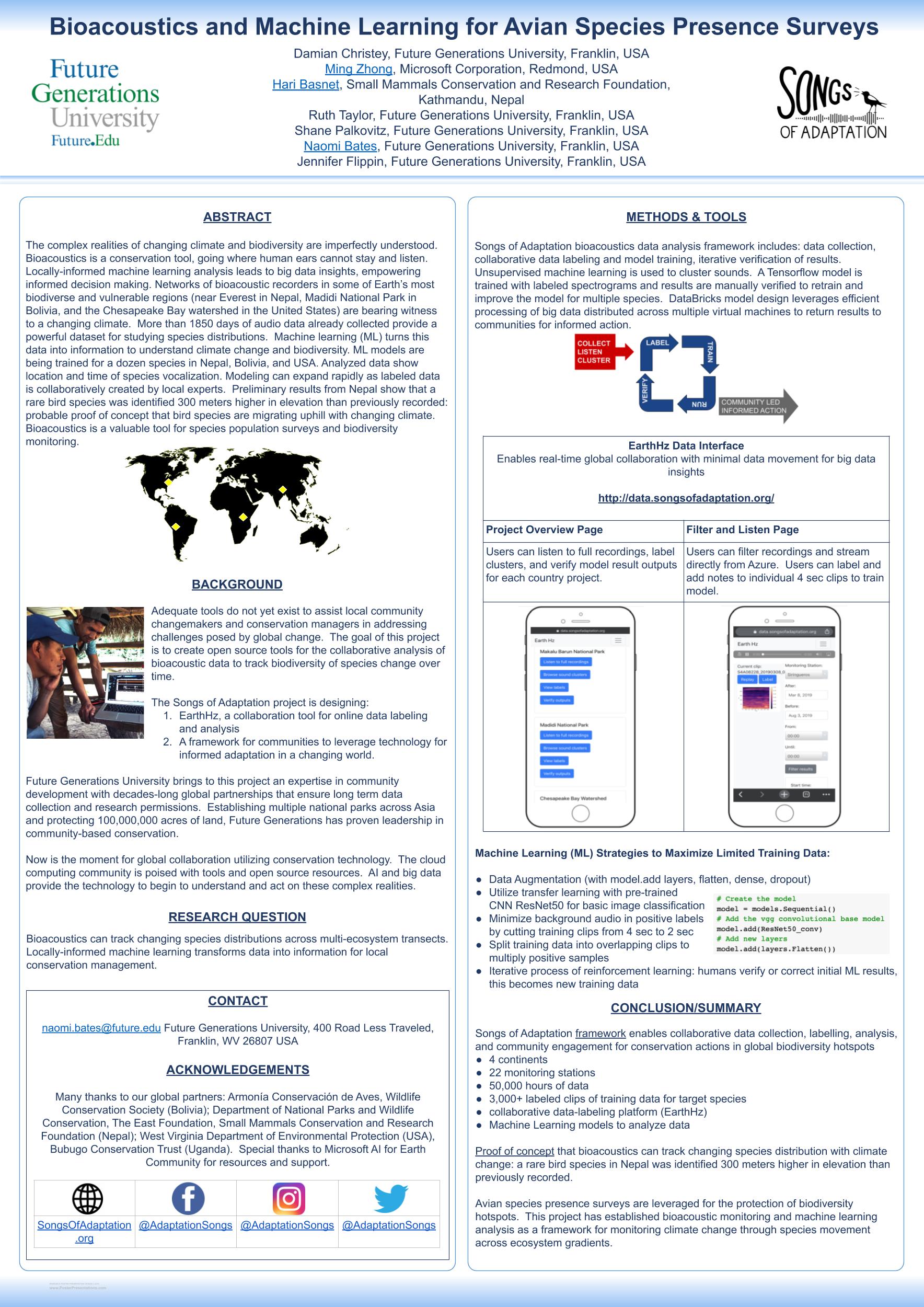
Open-source code
The projects funded by AI for Earth result in innovative solutions using AI and cloud computing. Build on the work of our AI for Earth grantees by exploring their open-source repositories.
-
Aberystwyth University
Classifying ice surface type in UAV or Sentinel-2 multispectral imagery
-
Academia Sinica
-
African Institute for Conservation, Primate and Predator Project
-
Agrimetrics
-
Airtonomy
-
Australian Rivers Institute
-
Avenging Forests
-
BearID Project
-
Boise State University
R scripts to import, manipulate, and iteratively sample LiDAR and Landsat data
-
Bridge 360 IT Solutions
-
Brigham Young University
-
Chicago Botanic Garden
Tools for downloading images that are relevant to conservation phenology
-
Colorado State University (CoCoRaHS Network)
Notebooks exploring AI analysis of volunteer-reported weather information
-
Conservation Metrics
Detecting bird species in acoustic recordings using the biophony model
-
Conservation Science Partners
R package for fitting the greenwave model to time series of vegetation indices
Deep learning ensemble for determining biomass from NAIP, LANDSAT, terrain features, and climate
Estimating forest structure using deep neural networks (Chimera-RCNN)
Sending spatial coordinates to Azure Open Datasets to retrieve imagery data -
Cornwall Seal Research Group
-
Duke University Marine Lab
Open source geoprocessing tutorial
Cetacean identification and photogrammetry
Detecting sea turtles in drone imagery -
Eberswalde University for Sustainable Development
-
EcoHealth Alliance
EcoHealth Alliance: researching connections between human and wildlife health
Extracting disease-related information from text
Reconstructing disease events as they are reported across different documents
Annotating epidemiological information in text documents
Using airline flight schedule data to map the commercial flight network -
Future Generations University
Web framework for sharing and collaboratively labeling bioacoustic data
Training CNNs for classifying acoustic signals -
Hokkaido University
-
IMT Atlantique
End-to-end learning of variational models and solvers using 4DVarNN
GeoTrackNet code for the detection of abnormal behaviour in AIS data streams
NbedDyn code for learning neural embedding for the modeling and simulation of partially-observed dynamical system
SubgirdTransportNN code for the learning of subgrid scale closures in transport equations -
Imperial College London
Finding cause-effect relationships between the Sustainable Development Goals and climate change
-
Indian Institute of Technology, Gandhinagar
Spatial Interpolation and sensor placement in Python
Visualizing air quality data -
Indian Institute of Technology, Guwahati
-
Indiana University
Identification of individual elephants
Recognizing individual Asian elephants -
International Maize and Wheat Improvement Center
Simulation of fertilizer application profitability for Tanzania
-
King's College London
-
Lancaster University
Installation of WRF on Azure and AWS VMs
Deployment of WRF model runs on Azure via MPI -
Let’s Do It Foundation
-
Massachusetts Institute of Technology
-
Natural Capital Project, Stanford University
-
Northeastern University
Climate downscaling using computer vision techniques in Python
-
Oklahoma State University
Python extensions to the Hydrological Simulation Program in Fortran (HSPF)
-
Research Institute of Rio de Janeiro Botanical Garden
modleR package - An ecological niche model workflow based on dismo
A workflow for ecological niche models
Conservation and restoration of the Doce River Basin -
Scripps Institute of Oceanography, University of California, San Diego
-
Stony Brook University
-
Surfrider Foundation Europe
-
Tanzania Conservation Resource Centre
AI-Assisted aerial imagery analysis for wildlife population monitoring
-
Technical University of Darmstadt
Forecasting El Nino-Southern Oscillation using spatiotemporal graph neural networks
Graph Neural Networks for Improved El Nino Forecasting -
U.S. Geological Survey
Optimizing the timing of herbicide application for buffelgrass control
-
Universidad Distrital Francisco Jose de Caldas
Processing high-resolution multispectral images for detecting and mapping late blight in potato crops
Multispectral imagery classification using pre-trained models -
University Hospital of Tuebingen
-
University of California Davis Center for Watershed Science
Optimization for environmental flows based on species assemblage data, using an evolutionary algorithm
Transforming species occurrence stream segment level -
University of California, Berkeley
-
University of California, Santa Barbara
Mapping fallow and irrigated center pivot agriculture from multispectral satellite imagery
Segmenting center pivot agriculture to monitor crop water use in drylands
Portfolio decision model for Tevere Basin
Using multi-scale representation learning for spatial feature distributions using grid cells in Python -
University of Colorado
Extraction of leaf trait data from herbarium vouchers using CNNs, SVMs, and CV algorithms
-
University of Denver
-
University of Maryland, College Park
Modeling child mortality
Mapping the effects of drought on child stunting
Scripts related to land cover and malnutrition -
University of Missouri
Classifying camera trap images based on sequence-level information
-
University of Nottingham, Malaysia
Siamese Recurrent Networks for sentence relatedness estimation.Trained models and PyTorch code
-
University of Oklahoma
-
University of Pittsburgh
OpenSoundscape: open-source, scalable software for the analysis of bioacoustic recordings
-
University of Saskatchewan
Efficient loss function for density map estimation for object counting
Lightweight segmentation network for aerial images with fine features
Plant phenotyping using counting and segmentation models in TensorFlow
Pretrained models and datasets for wheat plant counting and wheat biomass estimation -
University of South Florida
Processing scripts for decision-tree land use classification on worldview 2 imagery
-
University of Texas
-
University of Tuebingen
-
University of Washington
Identifying flower hotspots in subalpine meadows
Deep learning for weather prediction
Version of Clawpack for geophysical waves and flows
Using sequence information to improve camera trap image classification
DeepMicrobes: taxonomic classification for metagenomics with deep learning -
University of Wisconsin, Madison
-
Virginia Institute of Marine Science
-
Vivekanand Education Society’s Institute of Technology
Flood datasets and prediction model
Machine learning techniques for understanding the spread of Tuberculosis in India
Catchment prediction UI code
Predicting floods as a consequence of deforestation -
Washington State University
Accessing AIRPACT PM2.5 model output using Python
Mapping reported cases of Covid-19 for US counties
Data sets
AI for Earth grantees often release their training data to encourage others to build upon their work.
-
Adirondack Research
Adirondack Research Invasive Species Mapping
Interpolated lake characteristics data of twelve lakes, including depth, substrate hardness, and vegetation presence -
BeeLivingSensor
Boxes on Bees and Pollen
Images of bees annotated with bounding boxes on both bees and pollen -
Boise State University
Forest Canopy Height in Mexican Ecosystems
Aligned aerial imagery and vegetation height/structure information -
CityCollection
Images of household waste
~8000 images of household waste curated from Internet sources -
Defenders of Wildlife
Habitat change in the US
Polygons outlining areas of anthropogenic change visible in Sentinel-2 imagery of the United States -
Duke University
Aerial shellfish reefs
1kx1k, 2kx2k, and 4kx4k aerial images of oyster reefs labeled with boundaries, height, density, and coastal habitat typesAerial cetacean imagery
Aerial imagery and labels for individual humpback whales, minke whales, and blue whales and their length -
ETH Zürich
Phospholipids of sediment core
Boetius A, Damm E. Phospholipids of sediment core PS2441-1. Pangaea.de, 2003Micro-seismic and image data at Matterhorn
Micro-seismic and image dataset acquired at Matterhorn Hörnligrat, Switzerland -
Future Generations University
Bird songs in Nepal
Recordings of birds and other animals in Makalu Barun National Park, NepalBird songs in Bolivia
Recordings of birds and other animals in Madidi National Park, BoliviaBird songs in US
Recordings of birds and other animals in Chesapeake Bay watershed, USA -
Hokkaido University
Landslides and floods
Population outcomes in relation to landslides and floods (syndemics) -
IMT Atlantique
Sea surface height from satellite altimeter data
OSSE (Observing System Simulation Experiment) dataset for the space-time interpolation of sea surface height from satellite altimeter dataOcean waves and eddys
Dataset for the separation of wave and eddy dynamics in future SWOT observationsMaritime traffic
AIS dataset for maritime traffic monitoring -
Island Conservation
Island Conservation
Camera trap images from island ecosystems -
King Abdulaziz University
Detect and classify microorganisms in microscope images
A collection of datasets and neural networks for microorganism image classification -
NatureServe
Map of Biodiversity Importance
Habitat information for 2,216 imperiled species occurring in the conterminous United States. -
Orca Conservancy
Pod.Cast data archive
Acoustic data from hydrophones, for identification of orca calls -
RTA Technologies Pvt. Ltd.
Satellite images of clouds
Annotated cloud masks in satellite images -
SAEON
Global distribution of Clanwilliam cedar tree in 2013
13419 cedar tree localities that were mapped from 2013 Google Earth imagery -
Sky Pilot UAS
Aerial Seabirds West Africa
Aerial images of seabird colonies with point annotations -
Swedish Forest Agency
Forest Damages - Larch Casebearer
Drone images of trees with object-level annotations -
The Ocean Cleanup
Labeled plastic objects in river water
Bounding box annotations on overhead imagery of plastic debris -
University at Buffalo
Bali26
50,000 images of 26 ethnobotanically significant flora of Bali Indonesia -
University of Colorado, Boulder
Leaf images
Leaf images with vector overlay and labels from the Rhodes College collection -
University of Florida
NEON Tree Evaluation
A multisensor benchmark dataset for detecting individual trees in airborne RGB, Hyperspectral and LIDAR point clouds for 22 sites in the National Ecological Observation Network (NEON) -
University of Houston
Wildfire data for the south central US
Gridded monthly wildfire data and input variables -
University of Maryland, Baltimore County
Flood damage assessment after hurricanes
FloodNet: high resolution aerial imagery for post flood scene understanding -
Virginia Tech University and University of Brunei Darussalam
Borneo Bat Call Database
A collection of bat calls from the rainforests of Borneo -
Wild Me
Whale Shark ID
Images of whale sharks with individual-animal annotationsGreat Zebra and Giraffe Count and ID
Images of giraffes and zebras with individual-animal and count annotations -
Yale University
BaRAD (bias-adjusted radiation dataset)
Monthly bias-adjusted solar radiation from 1980 to 2019
Applications, APIs, demos, and models
AI for Earth helps to democratize access to AI tools and to enable everyone, everywhere to accelerate research, innovation, and solutions to our most urgent environmental challenges. Explore the tools that our AI for Earth grantees have developed to bring their work to the environmental science community.
-
Academia Sinica
-
Breeze Technologies
-
Brigham Young University
-
Centro del Muchacho Trabajador
-
Chulalongkorn University
-
Clouds On Mars
-
Conservation Science Partners
-
Duke University Marine Lab
-
Fish Angler
-
Perceptual Informatics
-
Scripps Institution of Oceanography
Model files and supporting data for integrated vapor transport forecasting
-
Trust for Public Land
-
University of California Santa Barbara
Python package for segmenting center pivot agriculture in satellite imagery
Keras model for segmenting center pivot agriculture in satellite imagery -
University of Florida
-
University of Glasgow
-
University of Haifa